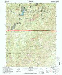
1994 Map of Mount Big Chief
USGS Topo · Published 1998About this map
Mount Big Chief and the high elevations of the Pike National Forest define this landscape along the complex borders of El Paso, Teller, and Fremont counties. The terrain is a network of ridges and drainages, where the Penrose-Rosemont Reservoir serves as a central water feature feeding into the East Fork and Beaver Creek. Human activity is marked by a history of transit and recreation, seen in the winding Gold Camp Road and Stage Road. Notable settlements and facilities like Broadmoor Lodge, Emerald Valley Ranch, and the Emerald Valley Boys Camp are scattered through the valleys, while the St Peters Dome Shooting Range sits near the summit of St Peters Dome. The map also documents industrial footprints through several quarries and prospect sites, illustrating the mixed use of this high-country environment in the late 20th century.
Find a feature on this map
50 named features on this map. Tap any name to fly to it.
Don’t see what you’re looking for? This feature index may not catch every label — zoom into the map to look around manually.
Map Details
Editions of this 1994 Mount Big Chief Map
This is the sole edition of this map. No revisions or reprints were ever made.
Other maps of this area

1893 · Colorado Springs
USGS Topo · 1:125,000

1894 · Pikes Peak
USGS Topo · 1:125,000

1901 · Pikes Peak
USGS Topo · 1:125,000

1901 · Pikes Peak
USGS Topo · 1:62,500

1909 · Colorado Springs
USGS Topo · 1:125,000

1942 · Colorado Springs
USGS Topo · 1:125,000

1948 · Mount Big Chief
USGS Topo · 1:24,000

1948 · Mount Pittsburg
USGS Topo · 1:24,000

1948 · Timber Mountain
USGS Topo · 1:24,000

1948 · Manitou Springs
USGS Topo · 1:24,000