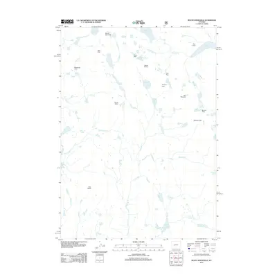
2012 Map of Mount Bonneville
USGS Topo · Published 2012About this map
Mount Bonneville stands as the centerpiece of this high-elevation landscape in the Wind River Range, where the continental divide carves through a network of alpine lakes and glacial features. The map documents a complex drainage system led by the E Fork River and Washakie Cr, fed by numerous high-altitude basins such as Bonneville Basin. High passes like Washakie Pass and Haily Pass suggest historic routes through this difficult terrain, connecting remote waters like Grave Lake and Baptiste Lake. Of particular note is the Hooker Glacier tucked beneath the shadow of Mount Hooker, providing a clear record of the area's remaining glacial ice and perennial snowfields as they appeared in 2012. The concentration of named peaks, including Mount Geikie and Raid Peak, emphasizes the territory's significance for survey work and mountain exploration.
Find a feature on this map
45 named features on this map. Tap any name to fly to it.
Don’t see what you’re looking for? This feature index may not catch every label — zoom into the map to look around manually.
Map Details
Editions of this 2012 Mount Bonneville Map
This is the sole edition of this map. No revisions or reprints were ever made.
Other maps of this area

1937 · Moccasin Lake
USGS Topo · 1:48,000

1938 · Mt Bonneville
USGS Topo · 1:62,500

1941 · Mt Bonneville
USGS Topo · 1:62,500

1942 · Mt Bonneville
USGS Topo · 1:62,500

1943 · Moccasin Lake
USGS Topo · 1:62,500

1955 · Lander
USGS Topo · 1:250,000

1958 · Lander
USGS Topo · 1:250,000

1961 · Lander
USGS Topo · 1:250,000

1969 · Pocket Creek Lake
USGS Topo · 1:24,000
1969 · Big Sandy Opening
USGS Topo · 1:24,000