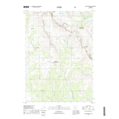
2017 Map of Mount Bonneville
USGS Topo · Published 2017About this map
The Continental Divide winds through this high-altitude landscape where the Fremont Co Sublette Co boundary meets the intersection of the Shoshone National Forest and the Bridger National Forest. The terrain is defined by dramatic peaks and high passes, including Mt Bonneville, Mt Geikie, and Mt Hooker, which tower over a dense network of glacial lakes and river headwaters. Notable water bodies such as Grave Lake, Baptiste Lake, and Pyramid Lake feed the E Fork River and various forks of the Washakie Cr. Primitive routes like the Continental Divide National Scenic Trail and the Highline trail provide the only access across these divides, navigating through key gaps like Washakie Pass and Hailey Pass. The presence of features like Twin Buttes and the Bonneville Basin illustrates the complex topography of this wilderness area.
Find a feature on this map
67 named features on this map. Tap any name to fly to it.
Don’t see what you’re looking for? This feature index may not catch every label — zoom into the map to look around manually.
Map Details
Editions of this 2017 Mount Bonneville Map
This is the sole edition of this map. No revisions or reprints were ever made.
Other maps of this area

1937 · Moccasin Lake
USGS Topo · 1:48,000

1938 · Mt Bonneville
USGS Topo · 1:62,500

1941 · Mt Bonneville
USGS Topo · 1:62,500

1942 · Mt Bonneville
USGS Topo · 1:62,500

1943 · Moccasin Lake
USGS Topo · 1:62,500

1955 · Lander
USGS Topo · 1:250,000

1958 · Lander
USGS Topo · 1:250,000

1961 · Lander
USGS Topo · 1:250,000

1969 · Pocket Creek Lake
USGS Topo · 1:24,000
1969 · Big Sandy Opening
USGS Topo · 1:24,000