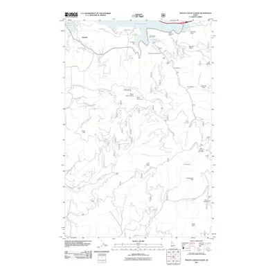
2011 Map of Mount Coeur D'Alene
USGS Topo · Published 2011About this map
Eddyville and the northern reaches of the Coeur d'Alene National Forest define this landscape along the eastern shores of Lake Coeur d'Alene. This terrain is marked by a legacy of resource extraction, with several named mining operations including the Caribou Mine, Gray Wolf Mine, and Silver Tip Mine situated on the slopes of the surrounding peaks. The topography rises sharply from Harrison Slough toward high points like Turner Peak and Mount Coeur D Alene, where fire lookouts such as the Elk Patrol Lookout and Mount Coeur D Alene Lookout were positioned to monitor the dense timber. A network of Forest Service roads, such as Natl Forest Develop Rd, connects these remote sites, while recreational spots like the Beauty Bay Picnic Area and Mineral Ridge Picnic Area line the waterfront, highlighting the area's transition toward recreation.
Find a feature on this map
53 named features on this map. Tap any name to fly to it.
Don’t see what you’re looking for? This feature index may not catch every label — zoom into the map to look around manually.
Map Details
Editions of this 2011 Mount Coeur D'Alene Map
This is the sole edition of this map. No revisions or reprints were ever made.
Other maps of this area

1903 · Rathdrum
USGS Topo · 1:125,000

1955 · Spokane
USGS Topo · 1:250,000

1957 · St. Maries
USGS Topo · 1:62,500

1957 · Plummer
USGS Topo · 1:62,500

1957 · Coeur D'Alene
USGS Topo · 1:62,500

1957 · Lane
USGS Topo · 1:62,500

1958 · Spokane
USGS Topo · 1:250,000

1975 · Coeur D'Alene SE
USGS Topo · 1:24,000

1975 · Plummer NE
USGS Topo · 1:24,000
1975 · Lane SW
USGS Topo · 1:24,000