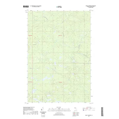
2019 Map of Mount Curwood
USGS Topo · Published 2019About this map
Mt Curwood rises as a prominent landmark in this interior portion of Baraga County, marking a landscape defined by an extensive network of waterways and historic industrial routes. The Huron Bay-Peshekee Grade and Peshekee Grade Rd trace a path through the timbered terrain, reflecting the area's history of resource transport toward the Great Lakes. A dense concentration of small glacial lakes, including High Life Lake, Camp Ten Lake, and Loon Lake, are connected by the headwaters of the Slate River, Ravine River, and the north-flowing E Br Silver River. The presence of the Celotex Rd suggests the enduring footprint of the regional forest products industry. This 2019 survey documents the intricate drainage patterns of the Peshekee River and W Br Peshekee River as they thread through the highlands of the Upper Peninsula.
Find a feature on this map
24 named features on this map. Tap any name to fly to it.
Don’t see what you’re looking for? This feature index may not catch every label — zoom into the map to look around manually.
Map Details
Editions of this 2019 Mount Curwood Map
This is the sole edition of this map. No revisions or reprints were ever made.
Other maps of this area

1954 · Skanee
USGS Topo · 1:62,500

1954 · Keweenaw Bay
USGS Topo · 1:62,500

1955 · Herman
USGS Topo · 1:62,500

1956 · Three Lakes
USGS Topo · 1:24,000

1956 · Michigamme
USGS Topo · 1:62,500

1956 · Michigamme
USGS Topo · 1:24,000

1958 · Iron River
USGS Topo · 1:250,000

1960 · Iron River
USGS Topo · 1:250,000

1961 · Iron River
USGS Topo · 1:250,000

1967 · Iron River
USGS Topo · 1:250,000