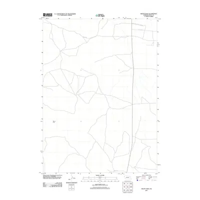
2011 Map of Mount Edna
USGS Topo · Published 2011About this map
Mount Edna stands as the primary landmark in this corner of Sioux County, overlooking a network of rural routes that crisscross the high plains. The northern edge of the map identifies the boundary of the Agate Fossil Beds Natl Monument, a region defined by its paleontological significance and unique geological formations. The land here remains largely open, characterized by the winding paths of Murphy Rd, Murphys Rd, and White Rock Rd. This survey highlights the sparse, expansive nature of the Nebraska panhandle, where topography is defined by subtle elevation changes and the preservation of ancient landscapes rather than dense settlement. The layout of these roads suggests a landscape still deeply connected to ranching and the preservation of natural history.
Find a feature on this map
5 named features on this map. Tap any name to fly to it.
Don’t see what you’re looking for? This feature index may not catch every label — zoom into the map to look around manually.
Map Details
Editions of this 2011 Mount Edna Map
This is the sole edition of this map. No revisions or reprints were ever made.
Other maps of this area

1899 · Whistle Creek
USGS Topo · 1:125,000

1955 · Alliance
USGS Topo · 1:250,000

1957 · Alliance
USGS Topo · 1:250,000

1958 · Alliance
USGS Topo · 1:250,000

1963 · Chalk Buttes
USGS Topo · 1:24,000

1979 · Mount Edna
USGS Topo · 1:24,000
1979 · Agate SW
USGS Topo · 1:24,000
1979 · Agate NW
USGS Topo · 1:24,000

1979 · Agate
USGS Topo · 1:24,000
1983 · Chalk Buttes NE
USGS Topo · 1:24,000