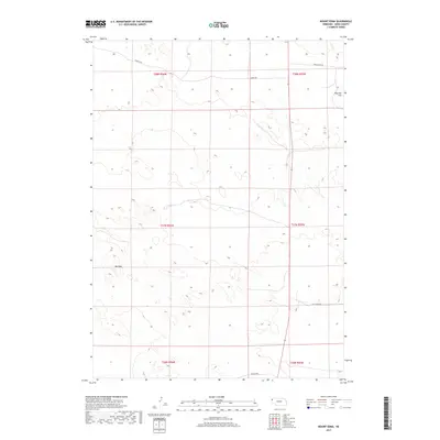
2017 Map of Mount Edna
USGS Topo · Published 2017About this map
Mt Edna rises as a prominent landmark in this high plains region of Sioux County, where the topography is defined by subtle elevation changes across a sparsely populated landscape. The survey captures the rural layout of Sheep Creek Precinct in the late 2010s, marked by a network of ranch and access roads including Murphy Rd, White Rock Rd, and Cut Across Rd. To the northeast, the terrain levels out at Royville Flat, illustrating the transition from rolling breaks to the more uniform surfaces common in this portion of Nebraska. The map provides a clear look at the Public Land Survey System grid, detailing the townships and ranges that have governed local property and land use since early settlement. This is an essential document for understanding the modern distribution of family ranching lands and the few named topographical features that orient travelers in the open country.
Find a feature on this map
12 named features on this map. Tap any name to fly to it.
Don’t see what you’re looking for? This feature index may not catch every label — zoom into the map to look around manually.
Map Details
Editions of this 2017 Mount Edna Map
This is the sole edition of this map. No revisions or reprints were ever made.
Other maps of this area

1899 · Whistle Creek
USGS Topo · 1:125,000

1955 · Alliance
USGS Topo · 1:250,000

1957 · Alliance
USGS Topo · 1:250,000

1958 · Alliance
USGS Topo · 1:250,000

1963 · Chalk Buttes
USGS Topo · 1:24,000

1979 · Mount Edna
USGS Topo · 1:24,000
1979 · Agate SW
USGS Topo · 1:24,000
1979 · Agate NW
USGS Topo · 1:24,000

1979 · Agate
USGS Topo · 1:24,000
1983 · Chalk Buttes NE
USGS Topo · 1:24,000