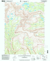
1996 Map of Mount Emmons
USGS Topo · Published 2000About this map
Mount Emmons dominates this high-altitude landscape in the Ashley National Forest, standing as a prominent peak within the High Uintas Wilderness. The region is defined by an intricate network of glacial basins and alpine water systems, most notably the Chain Lakes and Timothy Lakes clusters. These water bodies, along with Lake Atwood and the smaller Oke Doke Lake, feed into drainages like Atwood Creek and Swift Creek, illustrating the complex hydrology of the Uinta Range.
Find a feature on this map
40 named features on this map. Tap any name to fly to it.
Don’t see what you’re looking for? This feature index may not catch every label — zoom into the map to look around manually.
Map Details
Editions of this 1996 Mount Emmons Map
This is the sole edition of this map. No revisions or reprints were ever made.
Other maps of this area

1885 · Uinta
USGS Topo · 1:250,000

1905 · Gilbert Peak
USGS Topo · 1:125,000

1906 · Gilbert Peak
USGS Topo · 1:125,000

1954 · Salt Lake City
USGS Topo · 1:250,000

1958 · Salt Lake City
USGS Topo · 1:250,000

1960 · Salt Lake City
USGS Topo · 1:250,000

1965 · Mount Emmons
USGS Topo · 1:24,000
1965 · Heller Lake
USGS Topo · 1:24,000
1965 · Kings Peak
USGS Topo · 1:24,000
1965 · Bollie Lake
USGS Topo · 1:24,000