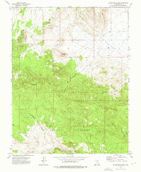
1972 Map of Mount Escalante
USGS Topo · Published 1976About this map
Dixie National Forest covers much of this high-desert terrain in Iron County, where the landscape is defined by a complex network of draws and ridges. During the early 1970s, the area served primarily as rugged grazing and timber land, accessible by remote routes like the Telegraph Trail and various jeep tracks. The topography rises toward Mount Escalante and Haystack Mountain, providing a clear view of the drainage patterns through Broad Hollow and Sevy Hollow. Names such as Nephi Draw and Studhorse Ridge suggest the region's ranching heritage and the influence of early settlers in southern Utah. This survey provides a precise look at the backcountry before modern recreation and land management changes, tracing the seasonal watercourses of Indian Draw and Canyon Draw.
Find a feature on this map
18 named features on this map. Tap any name to fly to it.
Don’t see what you’re looking for? This feature index may not catch every label — zoom into the map to look around manually.
Map Details
Editions of this 1972 Mount Escalante Map
This is the sole edition of this map. No revisions or reprints were ever made.
Other maps of this area

1885 · St. George
USGS Topo · 1:250,000

1885 · Pioche
USGS Topo · 1:250,000

1886 · Pioche
USGS Topo · 1:250,000

1891 · St. George
USGS Topo · 1:250,000

1953 · Cedar City
USGS Topo · 1:250,000

1954 · Caliente
USGS Topo · 1:250,000

1958 · Cedar City
USGS Topo · 1:250,000

1959 · Caliente
USGS Topo · 1:250,000

1962 · Cedar City
USGS Topo · 1:250,000
1972 · Uvada
USGS Topo · 1:24,000