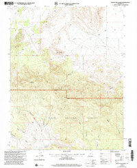
2002 Map of Mount Escalante
USGS Topo · Published 2005About this map
Dixie National Forest dominates this southwestern Utah landscape, particularly within the Pine Valley Ranger District. The terrain is characterized by a series of high ridges and deep drainages, anchored by the prominent elevations of Mount Escalante and Haystack Mountain. The map reveals a network of canyons and washes, including Broad Hollow, Sevy Hollow, and Horse Canyon, which define the local topography. This 2002 revision provides a look at the backcountry infrastructure used for land management and resource exploration, noted by features such as a Drill Hole and a Corral. The naming conventions of the various draws, such as Telegraph Draw, Studhorse Draw, and Nephi Draw, suggest the historical movements of early settlers and livestock through these high-altitude corridors. The absence of permanent settlements emphasizes the protected, wilderness character of this portion of Iron County.
Find a feature on this map
15 named features on this map. Tap any name to fly to it.
Don’t see what you’re looking for? This feature index may not catch every label — zoom into the map to look around manually.
Map Details
Editions of this 2002 Mount Escalante Map
This is the sole edition of this map. No revisions or reprints were ever made.
Other maps of this area

1885 · St. George
USGS Topo · 1:250,000

1885 · Pioche
USGS Topo · 1:250,000

1886 · Pioche
USGS Topo · 1:250,000

1891 · St. George
USGS Topo · 1:250,000

1953 · Cedar City
USGS Topo · 1:250,000

1954 · Caliente
USGS Topo · 1:250,000

1958 · Cedar City
USGS Topo · 1:250,000

1959 · Caliente
USGS Topo · 1:250,000

1962 · Cedar City
USGS Topo · 1:250,000
1972 · Uvada
USGS Topo · 1:24,000