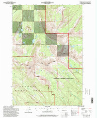
1996 Map of Mount Evans
USGS Topo · Published 1998About this map
The Continental Divide winds through this high-altitude landscape of southwestern Montana, marking the rugged spine between the Deerlodge National Forest and the Beaverhead National Forest. This 1996 update, based on mid-century topography and 1990s imagery, details the pristine alpine environments within the Anaconda Pintler Wilderness. Glacial activity is evident in the numerous tarns and basins, including Storm Lake and the Fourmile Basin Lakes tucked beneath peaks like Mount Evans and Mount Howe.
Find a feature on this map
28 named features on this map. Tap any name to fly to it.
Don’t see what you’re looking for? This feature index may not catch every label — zoom into the map to look around manually.
Map Details
Editions of this 1996 Mount Evans Map
This is the sole edition of this map. No revisions or reprints were ever made.
Other maps of this area

1908 · Philipsburg
USGS Topo · 1:125,000

1947 · Butte
USGS Topo · 1:250,000

1955 · Dillon
USGS Topo · 1:250,000

1957 · Dillon
USGS Topo · 1:250,000

1958 · Butte
USGS Topo · 1:250,000

1958 · Dillon
USGS Topo · 1:250,000

1960 · Butte
USGS Topo · 1:250,000

1962 · Butte
USGS Topo · 1:250,000

1962 · Dillon
USGS Topo · 1:250,000

1962 · Lincoln Gulch
USGS Topo · 1:24,000