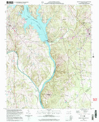
2002 Map of Mount Gilead West
USGS Topo · Published 2003About this map
Lake Pee Dee - River Tillery dominates the center of this landscape, where the waters of the Yadkin-Pee Dee river system meet at the Hydroelectric Plant and Hydro dam. This 2002 update of the topography reveals the intersection of four North Carolina counties—Stanly, Montgomery, Anson, and Richmond—along the riverbanks. The settlement of Mount Gilead sits to the east, while Norwood and its associated Norwood Beach occupy the western shore.
Find a feature on this map
40 named features on this map. Tap any name to fly to it.
Don’t see what you’re looking for? This feature index may not catch every label — zoom into the map to look around manually.
Map Details
Editions of this 2002 Mount Gilead West Map
This is the sole edition of this map. No revisions or reprints were ever made.
Other maps of this area

1942 · Troy
USGS Topo · 1:125,000

1953 · Raleigh
USGS Topo · 1:250,000

1953 · Charlotte
USGS Topo · 1:250,000

1954 · Charlotte
USGS Topo · 1:250,000

1954 · Raleigh
USGS Topo · 1:250,000

1956 · Mangum
USGS Topo · 1:24,000

1956 · Mount Gilead East
USGS Topo · 1:24,000

1956 · Ansonville
USGS Topo · 1:24,000

1956 · Mount Gilead West
USGS Topo · 1:24,000

1957 · Albemarle
USGS Topo · 1:62,500