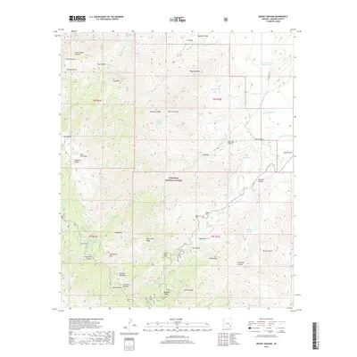
2018 Map of Mount Graham
USGS Topo · Published 2018About this map
Turkey Flat and the high ridges of the Pinaleno Mountains dominate this 2018 survey of the Coronado National Forest. The landscape is defined by extreme relief, descending from the heights of Heliograph Peak and Mt Graham toward the deep drainages of Marijilda Canyon and Jacobson Canyon. In the northeastern corner, human modification of the water table is evident through the Lebanon Ditch and Lebanon Reservoir Number One, infrastructure that supports agriculture in the drier basins below. Several high-altitude plains, including High Peak Cienega, Snow Flat, and Adams Flat, provide rare level ground amidst the steep slopes of Noon Creek Ridge and Veach Ridge. The map documents a network of springs such as Heliograph Spring and Hell-divi Spring, which are critical water sources in this vertical environment.
Find a feature on this map
59 named features on this map. Tap any name to fly to it.
Don’t see what you’re looking for? This feature index may not catch every label — zoom into the map to look around manually.
Map Details
Editions of this 2018 Mount Graham Map
This is the sole edition of this map. No revisions or reprints were ever made.
Other maps of this area

1942 · Mt. Graham
USGS Topo · 1:62,500

1945 · Mt. Graham
USGS Topo · 1:62,500

1954 · Silver City
USGS Topo · 1:250,000

1958 · Silver City
USGS Topo · 1:250,000

1960 · Thatcher
USGS Topo · 1:62,500

1960 · Safford
USGS Topo · 1:62,500

1962 · Silver City
USGS Topo · 1:250,000

1966 · Artesia
USGS Topo · 1:24,000
1966 · Gillespie Mtn.
USGS Topo · 1:24,000
1972 · Mt. Graham
USGS Topo · 1:24,000