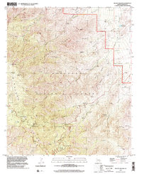
1996 Map of Mount Graham
USGS Topo · Published 2002About this map
The Pinaleño Mountains dominate this 1996 survey, rising to the summit of Mt Graham and High Peak within the Coronado National Forest. This high-altitude landscape is defined by its recreation and fire-watch infrastructure, including a Lookout Tower and Communication Facility atop Heliograph Peak. The map records the settlement at Turkey Flat and a network of high-country sites like Snow Flat and Springs Treasure Park.
Find a feature on this map
73 named features on this map. Tap any name to fly to it.
Don’t see what you’re looking for? This feature index may not catch every label — zoom into the map to look around manually.
Map Details
Editions of this 1996 Mount Graham Map
This is the sole edition of this map. No revisions or reprints were ever made.
Other maps of this area

1942 · Mt. Graham
USGS Topo · 1:62,500

1945 · Mt. Graham
USGS Topo · 1:62,500

1954 · Silver City
USGS Topo · 1:250,000

1958 · Silver City
USGS Topo · 1:250,000

1960 · Thatcher
USGS Topo · 1:62,500

1960 · Safford
USGS Topo · 1:62,500

1962 · Silver City
USGS Topo · 1:250,000

1966 · Artesia
USGS Topo · 1:24,000
1966 · Gillespie Mtn.
USGS Topo · 1:24,000
1972 · Mt. Graham
USGS Topo · 1:24,000