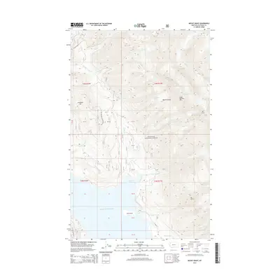
2014 Map of Mount Grant
USGS Topo · Published 2014About this map
Flathead National Forest dominates this mountain landscape, where the high peaks of the Flathead Range meet the deep waters of the Hungry Horse Reservoir. The map documents a wilderness shaped by massive geological and hydrological features, including the Stanton Glacier and Grant Glacier clinging to the slopes of Great Northern Mtn and Mt Grant. In the southern reaches, the reservoir creates distinct geographic markers like Riverside Bay and Kelly Island. The terrain is deeply incised by numerous drainages such as Stanton Cr, Hungry Horse Cr, and McInernie Cr, which flow from the summits of Firefighter Mtn and Mt Murray. Access is limited to remote corridors like Natl Forest Develop Road 3818 RD and the E Side RD, reflecting the area's primary role as a managed forest and watershed within the Flathead Valley region.
Find a feature on this map
42 named features on this map. Tap any name to fly to it.
Don’t see what you’re looking for? This feature index may not catch every label — zoom into the map to look around manually.
Map Details
Editions of this 2014 Mount Grant Map
This is the sole edition of this map. No revisions or reprints were ever made.
Other maps of this area

1914 · Nyack
USGS Topo · 1:125,000

1958 · Felix Peak
USGS Topo · 1:24,000

1960 · Cut Bank
USGS Topo · 1:250,000

1963 · Cut Bank
USGS Topo · 1:250,000

1964 · Cut Bank
USGS Topo · 1:250,000
1964 · Jewel Basin
USGS Topo · 1:24,000

1964 · Nyack
USGS Topo · 1:24,000

1964 · Pinnacle
USGS Topo · 1:24,000

1964 · Stanton Lake
USGS Topo · 1:24,000
1964 · Nyack SW
USGS Topo · 1:24,000