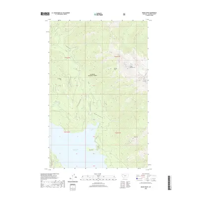
2020 Map of Mount Grant
USGS Topo · Published 2020About this map
Hungry Horse Reservoir dominates the southern reaches of this landscape, its waters reaching into Riverside Bay and surrounding Kelly Island. The terrain is defined by the high peaks of the Flathead Range, including the prominent Great Northern Mtn, Mt Grant, and Firefighter Mtn. These summits and ridges, such as Grant Ridge, partition a network of drainage basins where Tiger Cr, Stanton Cr, and Murray Cr flow through the Flathead National Forest. Access to this high-elevation backcountry is provided by a system of forest development roads, notably E Side Rd and the Highline Loop Rd, which trace the contours of the steep slopes. The map detail illustrates the complex relationship between the managed timberlands and the hydrologic power of the reservoir system in the modern era.
Find a feature on this map
37 named features on this map. Tap any name to fly to it.
Don’t see what you’re looking for? This feature index may not catch every label — zoom into the map to look around manually.
Map Details
Editions of this 2020 Mount Grant Map
This is the sole edition of this map. No revisions or reprints were ever made.
Other maps of this area

1914 · Nyack
USGS Topo · 1:125,000

1958 · Felix Peak
USGS Topo · 1:24,000

1960 · Cut Bank
USGS Topo · 1:250,000

1963 · Cut Bank
USGS Topo · 1:250,000

1964 · Cut Bank
USGS Topo · 1:250,000
1964 · Jewel Basin
USGS Topo · 1:24,000

1964 · Nyack
USGS Topo · 1:24,000

1964 · Pinnacle
USGS Topo · 1:24,000

1964 · Stanton Lake
USGS Topo · 1:24,000
1964 · Nyack SW
USGS Topo · 1:24,000