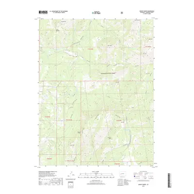
2019 Map of Mount Guero
USGS Topo · Published 2019About this map
Gunnison National Forest spans this high-elevation landscape, where complex water management and seasonal recreation routes define the human presence. The northern reaches are carved by the Smith Fork Gunnison River and its tributaries, including Lone Pine Cr and Sink Creek. Engineering for irrigation is evident in the Virginia Ditch, which follows the contours of the terrain near Castle Rock. In the southern portion of the quadrangle, the high-altitude Bald Mountain Reservoir sits below Bald Mtn, serving as a critical water source for the region. Movement through these peaks is facilitated by specialized routes like the Through Line (Hawksnest) and the Crystal Creek Snowmobile/Ski trail. Prominent landforms such as Mendicant Ridge and Mt Guero provide a dramatic backdrop to the various forest roads like Piburn and the Bald Mountain Tie In.
Find a feature on this map
48 named features on this map. Tap any name to fly to it.
Don’t see what you’re looking for? This feature index may not catch every label — zoom into the map to look around manually.
Map Details
Editions of this 2019 Mount Guero Map
This is the sole edition of this map. No revisions or reprints were ever made.
Other maps of this area

1938 · Mt. Gunnison
USGS Topo · 1:48,000

1945 · Mount Gunnison
USGS Topo · 1:62,500

1954 · Little Soap Park
USGS Topo · 1:24,000

1956 · Montrose
USGS Topo · 1:250,000

1957 · Cathedral Peak
USGS Topo · 1:24,000

1957 · X Lazy F Ranch
USGS Topo · 1:24,000

1959 · Montrose
USGS Topo · 1:250,000

1960 · Montrose
USGS Topo · 1:250,000
1964 · West Beckwith Peak
USGS Topo · 1:24,000

1964 · Minnesota Pass
USGS Topo · 1:24,000