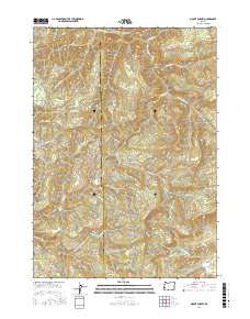
2017 Map of Mount Gurney
USGS Topo · Published 2017About this map
The Williams River and its numerous tributaries, including Fivemile Cr and Wilson Cr, carve through this heavily ridged landscape along the border of Coos and Douglas counties. This 2017 study illustrates a region dominated by timber and resource management, defined by an intricate network of Bureau of Land Management and forestry access roads like the Burnt Ridge Rd and various WTC-designated routes. Elevations reach their peak at Mount Gurney and Bear Mtn, while the terrain is marked by prominent landmarks such as Buzzard Rock and Bennett Rock.
Find a feature on this map
64 named features on this map. Tap any name to fly to it.
Don’t see what you’re looking for? This feature index may not catch every label — zoom into the map to look around manually.
Map Details
Editions of this 2017 Mount Gurney Map
This is the sole edition of this map. No revisions or reprints were ever made.
Other maps of this area

1928 · Sitkum
USGS Topo · 1:125,000

1955 · Camas Valley
USGS Topo · 1:62,500

1955 · Ivers Peak
USGS Topo · 1:62,500

1955 · Sitkum
USGS Topo · 1:62,500

1955 · Tyee
USGS Topo · 1:62,500

1958 · Roseburg
USGS Topo · 1:250,000

1959 · Roseburg
USGS Topo · 1:250,000

1979 · Roseburg
USGS Topo · 1:100,000
1990 · Cedar Creek
USGS Topo · 1:24,000
1990 · Tenmile
USGS Topo · 1:24,000