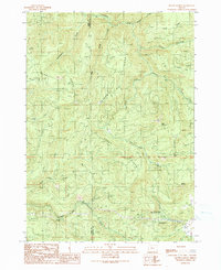
1990 Map of Mount Gurney
USGS Topo · Published 1990About this map
Burnt Ridge and Threemile Ridge define the steep, drainage-heavy terrain of this Douglas and Coos County borderland during the late 1980s. The landscape is characterized by a dense network of watercourses, including the Williams River and the Brewster Fork Coquille River, which carve through the high elevations of Mount Gurney and Bear Mountain. Human presence is marked by the small settlement of Tioga and several localized industrial sites labeled simply as Quarry. The map provides a detailed view of local recreation and memorial spaces, specifically the Severt Iverson Memorial County Park and Dave Busenbark County Park, located along the southern reaches of Tenmile Creek. Notable natural landmarks such as Lost Creek Falls and the jagged prominence of Buzzard Rock stand out as significant topographic features in this heavily timbered region of the Pacific Northwest.
Find a feature on this map
26 named features on this map. Tap any name to fly to it.
Don’t see what you’re looking for? This feature index may not catch every label — zoom into the map to look around manually.
Map Details
Editions of this 1990 Mount Gurney Map
This is the sole edition of this map. No revisions or reprints were ever made.
Other maps of this area

1928 · Sitkum
USGS Topo · 1:125,000

1955 · Camas Valley
USGS Topo · 1:62,500

1955 · Ivers Peak
USGS Topo · 1:62,500

1955 · Sitkum
USGS Topo · 1:62,500

1955 · Tyee
USGS Topo · 1:62,500

1958 · Roseburg
USGS Topo · 1:250,000

1959 · Roseburg
USGS Topo · 1:250,000

1979 · Roseburg
USGS Topo · 1:100,000
1990 · Cedar Creek
USGS Topo · 1:24,000
1990 · Tenmile
USGS Topo · 1:24,000