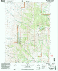
2001 Map of Mount Harrison
USGS Topo · Published 2006About this map
Mount Harrison dominates the high-altitude landscape of the Albion Mountains, serving as a central landmark within the Sawtooth National Forest. This 2001 revision of the local topography reveals a region defined by sharp elevation changes and essential water resources. At the high peaks, the Lake Cleveland Complex and Lake Cleveland indicate a hub for recreation and seasonal residency, specifically at the Thompson Flat Summer Home Area.
Find a feature on this map
42 named features on this map. Tap any name to fly to it.
Don’t see what you’re looking for? This feature index may not catch every label — zoom into the map to look around manually.
Map Details
Editions of this 2001 Mount Harrison Map
This is the sole edition of this map. No revisions or reprints were ever made.
Other maps of this area

1954 · Pocatello
USGS Topo · 1:250,000

1958 · Pocatello
USGS Topo · 1:250,000

1964 · View
USGS Topo · 1:24,000

1964 · Kenyon
USGS Topo · 1:24,000

1968 · Cache Peak
USGS Topo · 1:24,000

1968 · Basin
USGS Topo · 1:24,000

1968 · Marion SE
USGS Topo · 1:24,000

1968 · Elba
USGS Topo · 1:24,000

1968 · Mount Harrison
USGS Topo · 1:24,000

1968 · Albion
USGS Topo · 1:24,000