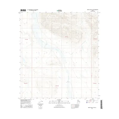
2016 Map of Mount Hayes A-2 SW
USGS Topo · Published 2016About this map
The Chistochina River and its complex network of tributaries define this interior Alaska landscape, where the braided riverbed carves a broad valley through the mountainous terrain. This 2016 survey highlights the hydrology of the Unorganized Borough, documenting the flow of the Chisna River and its intersection with numerous smaller creeks. The drainages of Gold Cr and Daisy Cr indicate a landscape shaped by glacial and alpine runoff, providing essential data for those studying the remote northern wilderness. The map is a meticulous record of land divisions, including townships such as t21s r15e and t22s r15e, which organize this largely uninhabited territory. Geologic features like Red Mountain Cr and Rock Cr offer insight into the topographical character of the Copper River basin's northern reaches.
Find a feature on this map
13 named features on this map. Tap any name to fly to it.
Don’t see what you’re looking for? This feature index may not catch every label — zoom into the map to look around manually.
Map Details
Editions of this 2016 Mount Hayes A-2 SW Map
This is the sole edition of this map. No revisions or reprints were ever made.
Other maps of this area

1949 · Gulkana D-3
USGS Topo · 1:63,360

1950 · Mount Hayes
USGS Topo · 1:250,000

1950 · Mount Hayes A-3
USGS Topo · 1:63,360

1951 · Gulkana
USGS Topo · 1:250,000

1951 · Mount Hayes
USGS Topo · 1:250,000

1952 · Gulkana D-3
USGS Topo · 1:63,360

1952 · Mount Hayes A-3
USGS Topo · 1:63,360
1954 · Gulkana D-2
USGS Topo · 1:63,360
1954 · Gulkana D-3
USGS Topo · 1:63,360
1954 · Mount Hayes A-3
USGS Topo · 1:63,360