1954 Map of Gulkana D-2
USGS Topo · Published 1958About this map
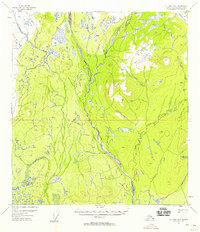
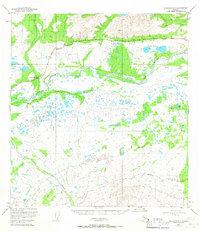
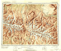
Chistochina River and its intricate drainage system dominate this mid-century topographic survey of the Alaskan interior. The landscape is defined by the convergence of the Middle Fork and East Fork, creating a vast braided river network that dictates movement through the region. In an era when permanent infrastructure was scarce, transportation relied heavily on the Tractor Trail winding through the valley, providing a critical link for early territorial travelers. Mankomen Lake sits in the northeast corner, a prominent landmark amidst a terrain marked by numerous unnamed creeks and marshes. While most of the area remains undeveloped wilderness, isolated cabins along the watercourses and trails signify the sparse, functional settlement patterns of 1950s Alaska. Sinona Creek further illustrates the complex hydrological character of this subarctic environment before the expansion of modern roadways.
Find a feature on this map
8 named features on this map. Tap any name to fly to it.
Don’t see what you’re looking for? This feature index may not catch every label — zoom into the map to look around manually.
Map Details
Editions of this 1954 Gulkana D-2 Map
3 editions found

Other maps of this area
1949 · Gulkana C-2
USGS Topo · 1:63,360
1949 · Gulkana D-3
USGS Topo · 1:63,360
1949 · Gulkana C-1
USGS Topo · 1:63,360

1949 · Mt. Hayes A-1
USGS Topo · 1:63,360

1950 · Mount Hayes
USGS Topo · 1:250,000
1950 · Mount Hayes A-3
USGS Topo · 1:63,360
1950 · Gulkana C-3
USGS Topo · 1:63,360
1951 · Gulkana
USGS Topo · 1:250,000
1951 · Mount Hayes
USGS Topo · 1:250,000
1952 · Gulkana D-3
USGS Topo · 1:63,360