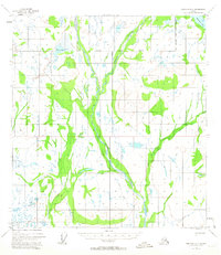
1954 Map of Gulkana D-2
USGS Topo · Published 1963About this map
The Chistochina River and its major tributaries dominate this subarctic landscape during the mid-1950s, revealing a wilderness defined by its watercourses and seasonal routes. The confluence of the Middle Fork and East Fork with the main river channel creates a complex network of braided streams and alluvial plains. Human presence is sparse and utilitarian, represented by a singular Mine and a network of Winter Trails that provide essential overland access across the frozen terrain when the marshes and waterways are impassable. To the west, Sinona Lake and Sinona Creek drain through a series of wetland basins, while the northeast corner is marked by the presence of Monkomen Lake. This map captures a moment before significant modern development, where the Bureau of Land Management used aerial photography to predetermine land lines across the unsurveyed interior of the Copper River and Fairbanks meridians.
Find a feature on this map
10 named features on this map. Tap any name to fly to it.
Don’t see what you’re looking for? This feature index may not catch every label — zoom into the map to look around manually.
Map Details
Editions of this 1954 Gulkana D-2 Map
3 editions found
Other maps of this area

1949 · Gulkana C-2
USGS Topo · 1:63,360

1949 · Gulkana D-3
USGS Topo · 1:63,360

1949 · Gulkana C-1
USGS Topo · 1:63,360

1949 · Mt. Hayes A-1
USGS Topo · 1:63,360

1950 · Mount Hayes
USGS Topo · 1:250,000

1950 · Mount Hayes A-3
USGS Topo · 1:63,360

1950 · Gulkana C-3
USGS Topo · 1:63,360

1951 · Gulkana
USGS Topo · 1:250,000

1951 · Mount Hayes
USGS Topo · 1:250,000

1952 · Gulkana D-3
USGS Topo · 1:63,360