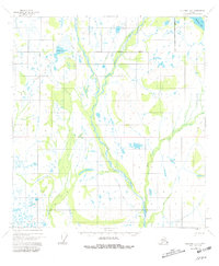
1954 Map of Gulkana D-2
USGS Topo · Published 1981About this map
The Chistochina River and its glacial tributaries dominate this interior Alaskan landscape, recorded as it appeared in the mid-1950s. The braided river system, including the Middle Fork and East Fork, carves through a terrain marked by extensive wetlands and lakes such as Mankomen Lake and Sinona Lake. Human presence in this wilderness is sparse, indicated primarily by a Winter Trail that cuts across the northern reaches and isolated structures like a Cabin and a remote Mine located east of the main river channel. This map illustrates the intersection of the Copper River and Fairbanks Meridians, showing the vast, undeveloped stretches of the eastern Alaska Range foothills before modern infrastructure or significant industrial expansion reached this specific quadrant.
Find a feature on this map
11 named features on this map. Tap any name to fly to it.
Don’t see what you’re looking for? This feature index may not catch every label — zoom into the map to look around manually.
Map Details
Editions of this 1954 Gulkana D-2 Map
3 editions found
Other maps of this area

1949 · Gulkana C-2
USGS Topo · 1:63,360

1949 · Gulkana D-3
USGS Topo · 1:63,360

1949 · Gulkana C-1
USGS Topo · 1:63,360

1949 · Mt. Hayes A-1
USGS Topo · 1:63,360

1950 · Mount Hayes
USGS Topo · 1:250,000

1950 · Mount Hayes A-3
USGS Topo · 1:63,360

1950 · Gulkana C-3
USGS Topo · 1:63,360

1951 · Gulkana
USGS Topo · 1:250,000

1951 · Mount Hayes
USGS Topo · 1:250,000

1952 · Gulkana D-3
USGS Topo · 1:63,360