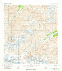
1955 Map of Mount Hayes B-2
USGS Topo · Published 1963About this map
Glacial ice and high-altitude drainage systems dominate this mid-century survey of the Alaska interior. The Johnson Glacier and Kimball Glacier feed a network of cold-water streams, including the Johnson River and Elting Creek, which carve through the high terrain before reaching the lower valleys. This map shows the landscape as it was documented in the mid-1950s, highlighting the expansive Crevasses and ice fields that defined the region before modern climatic shifts. The eastern portion of the quadrangle is marked by the West Fork Robertson River and the massive Robertson Glacier, providing a detailed look at the hydrological divide along the Copper River Meridian. Without established roads or settlements at the time of the survey, the map focuses on the raw physical geography and named landmarks like Sandslide Creek.
Find a feature on this map
9 named features on this map. Tap any name to fly to it.
Don’t see what you’re looking for? This feature index may not catch every label — zoom into the map to look around manually.
Map Details
Editions of this 1955 Mount Hayes B-2 Map
2 editions found

Other maps of this area

1949 · Mt. Hayes A-1
USGS Topo · 1:63,360

1950 · Mount Hayes
USGS Topo · 1:250,000

1950 · Mount Hayes A-3
USGS Topo · 1:63,360

1951 · Mount Hayes
USGS Topo · 1:250,000

1952 · Mount Hayes A-3
USGS Topo · 1:63,360

1954 · Mount Hayes B-1
USGS Topo · 1:63,360

1954 · Mount Hayes C-3
USGS Topo · 1:63,360
1954 · Mount Hayes A-1
USGS Topo · 1:63,360

1954 · Mount Hayes C-1
USGS Topo · 1:63,360
1954 · Mount Hayes A-3
USGS Topo · 1:63,360