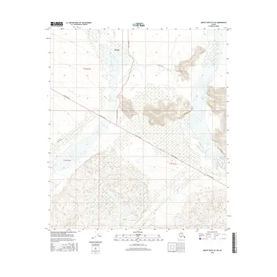
2016 Map of Mount Hayes D-2 SW
USGS Topo · Published 2016About this map
Deltana sits at a critical junction in the Alaskan interior where the massive braid of the Gerstle River flows northward toward the Tanana River. This survey captures the complex drainage systems and expansive wetlands characteristic of the Tanana Valley. The landscape is defined by the rigid line of the Alaska Highway, which cuts diagonally across the fluvial plains, providing a vital artery through the wilderness. Local access routes like Cummings Street and Atkinsons Road extend into the surrounding terrain, while the Little Gerstle River and Dougherty Cr snake through the lower elevations. The map reveals the intricate interplay between high-speed transportation infrastructure and the volatile, shifting gravel bars of major glacial river systems.
Find a feature on this map
13 named features on this map. Tap any name to fly to it.
Don’t see what you’re looking for? This feature index may not catch every label — zoom into the map to look around manually.
Map Details
Editions of this 2016 Mount Hayes D-2 SW Map
This is the sole edition of this map. No revisions or reprints were ever made.
Other maps of this area

1950 · Mount Hayes
USGS Topo · 1:250,000

1951 · Mount Hayes
USGS Topo · 1:250,000

1954 · Mount Hayes C-3
USGS Topo · 1:63,360

1954 · Mount Hayes D-2
USGS Topo · 1:63,360

1954 · Mount Hayes D-3
USGS Topo · 1:63,360

1955 · Mount Hayes C-2
USGS Topo · 1:63,360

1955 · Mount Hayes D-2
USGS Topo · 1:63,360
1955 · Mount Hayes D-3
USGS Topo · 1:63,360

1955 · Mount Hayes C-3
USGS Topo · 1:63,360

1955 · Mount Hayes
USGS Topo · 1:250,000