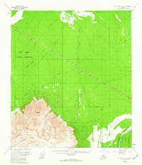
1955 Map of Mount Hayes D-3
USGS Topo · Published 1963About this map
The Fort Greely Military Reservation dominates the northern half of this mid-century Alaskan landscape, sliced through by the vital corridor of the Alaska Highway. This survey captures a moment when post-war infrastructure began to define the interior, showing the highway as a primary artery across a network of drainage systems like Sawmill Creek and Rhoads Creek. To the south, the topography shifts abruptly into the high elevations of the Granite Mountains, where distinctive landmarks such as Panoramic Peak, Jagged Mountain, and the Boulder Plateau rise above the glacial valleys. The presence of the Winter Trail near the Gerstle River illustrates the seasonal nature of movement in this subarctic environment, while labels like Hajdukovich Creek hint at the local human history tied to specific waterways and mountain approaches.
Find a feature on this map
16 named features on this map. Tap any name to fly to it.
Don’t see what you’re looking for? This feature index may not catch every label — zoom into the map to look around manually.
Map Details
Editions of this 1955 Mount Hayes D-3 Map
2 editions found
Other maps of this area

1950 · Mount Hayes
USGS Topo · 1:250,000

1950 · Big Delta
USGS Topo · 1:250,000

1950 · Mount Hayes D-4
USGS Topo · 1:63,360

1950 · Mount Hayes C-4
USGS Topo · 1:63,360

1950 · Big Delta A-4
USGS Topo · 1:63,360

1951 · Big Delta
USGS Topo · 1:250,000

1951 · Mount Hayes
USGS Topo · 1:250,000

1952 · Mount Hayes D-4
USGS Topo · 1:63,360

1952 · Mount Hayes C-4
USGS Topo · 1:63,360

1952 · Big Delta A-4
USGS Topo · 1:63,360