
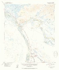
1952 Map of Big Delta A-4
USGS Topo · Published 1952About this map
Tanana River and Delta River converge in this Alaskan interior landscape, framing a critical transportation corridor during the early 1950s. The convergence area is marked by significant landmarks of the era, including Bert & Marys Roadhouse and the settlement of Big Delta (Aband), which is noted as abandoned on this sheet. The emergence of Delta Junction and Buffalo Center at the intersection of the Richardson Highway and Alaska Highway illustrates the shift in regional activity toward these motorized transport routes. North of the confluence, Quartz Lake and the Shaw Creek Flats dominate the terrain, while numerous smaller outposts such as Jollys Cabins and Bluff Cabin dot the banks of the Goodpaster River, reflecting a period when remote cabins and roadhouses were central to travel and commerce in the territory.
Find a feature on this map
30 named features on this map. Tap any name to fly to it.
Don’t see what you’re looking for? This feature index may not catch every label — zoom into the map to look around manually.
Map Details
Editions of this 1952 Big Delta A-4 Map
2 editions found
Other maps of this area

1949 · Big Delta B-5
USGS Topo · 1:63,360

1950 · Mount Hayes
USGS Topo · 1:250,000

1950 · Big Delta
USGS Topo · 1:250,000

1950 · Big Delta A-5
USGS Topo · 1:63,360

1950 · Mount Hayes D-4
USGS Topo · 1:63,360

1950 · Big Delta A-4
USGS Topo · 1:63,360

1950 · Mount Hayes D-5
USGS Topo · 1:63,360

1950 · Big Delta B-4
USGS Topo · 1:63,360

1951 · Big Delta
USGS Topo · 1:250,000

1951 · Mount Hayes
USGS Topo · 1:250,000