
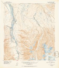
1952 Map of Mount Hayes C-4
USGS Topo · Published 1952About this map
The Delta River valley dominates this interior Alaskan landscape, serving as the primary corridor for the Richardson Highway. This high-latitude environment shows the vital infrastructure supporting transit and logistics in the early 1950s, anchored by the Rapids Roadhouse and the nearby Rapids Airstrip. These sites provided essential refuge and supply points for travelers moving between the coast and the interior. To the east, the terrain rises sharply toward jagged peaks, drained by complex braided systems like Jarvis Creek and Little Gold Creek. The southern edge is defined by the massive Black Rapids Glacier, which flows toward the river valley. Numerous family-named and geographic landmarks such as Buffalo and McCumber Creek provide specific points of reference for those tracking early territorial development, bush flying history, or high-altitude geological survey markers in the Mount Hayes region.
Find a feature on this map
24 named features on this map. Tap any name to fly to it.
Don’t see what you’re looking for? This feature index may not catch every label — zoom into the map to look around manually.
Map Details
Editions of this 1952 Mount Hayes C-4 Map
2 editions found
Other maps of this area

1950 · Mount Hayes
USGS Topo · 1:250,000

1950 · Mount Hayes D-4
USGS Topo · 1:63,360

1950 · Mount Hayes C-4
USGS Topo · 1:63,360

1950 · Mount Hayes D-5
USGS Topo · 1:63,360

1951 · Mount Hayes
USGS Topo · 1:250,000

1951 · Mount Hayes C-5
USGS Topo · 1:63,360

1951 · Mt. Hayes B-5
USGS Topo · 1:63,360

1952 · Mount Hayes D-5
USGS Topo · 1:63,360

1952 · Mount Hayes D-4
USGS Topo · 1:63,360

1952 · Mount Hayes B-4
USGS Topo · 1:63,360