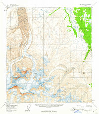
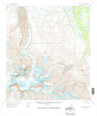
1951 Map of Mount Hayes C-5
USGS Topo · Published 1961About this map
Trident Glacier dominates the western half of this subarctic terrain, joined by a complex network of crevasses and ice fields that flow through the Alaska Range. Surveyed between 1949 and 1956, this topographical study highlights the massive scale of the high-altitude peaks, including the 13,000-foot heights near Mount Moffit and the prominent McGinnis Peak. The eastern portion of the map transitions into the steep drainage of the McGinnis Glacier, while summits such as Mount Shand and Mount Pillsbury mark the southern divide. This area remains largely untouched by roads or permanent structures, with the Bureau of Land Management predetermining land lines for unsurveyed territory. The map provides a precise record of glacial positions and elevations before late-twentieth-century shifts, including specific benchmarks like VABM 7897 Gale.
Find a feature on this map
9 named features on this map. Tap any name to fly to it.
Don’t see what you’re looking for? This feature index may not catch every label — zoom into the map to look around manually.
Map Details
Editions of this 1951 Mount Hayes C-5 Map
3 editions found
Historical Maps of Unorganized Borough Through Time
634 maps found

1899 Fortymile
Southeast Fairbanks Borough, AK

1948 Tanacross A-3
Southeast Fairbanks Borough, AK

1948 Tanacross A-4
Southeast Fairbanks Borough, AK

1948 Tanacross A-5
Southeast Fairbanks Borough, AK

1948 Tanacross A-6
Southeast Fairbanks Borough, AK

1948 Tanacross B-3
Southeast Fairbanks Borough, AK

1948 Tanacross B-5
Southeast Fairbanks Borough, AK

1949 Big Delta A-6
Southeast Fairbanks Borough, AK

1949 Tanacross A-5
Southeast Fairbanks Borough, AK

1949 Tanacross B-3
Southeast Fairbanks Borough, AK

1949 Tanacross B-4
Southeast Fairbanks Borough, AK

1949 Tanacross B-6
Southeast Fairbanks Borough, AK

1950 Big Delta A-4
Southeast Fairbanks Borough, AK

1950 Big Delta A-5
Southeast Fairbanks Borough, AK

1950 Big Delta B-4
Southeast Fairbanks Borough, AK

1950 Mount Hayes D-5
Southeast Fairbanks Borough, AK

1950 Mount Hayes D-6
Southeast Fairbanks Borough, AK

1950 Mount Hayes
Southeast Fairbanks Borough, AK

1950 Mt. Hayes C-4
Southeast Fairbanks Borough, AK

1950 Mt. Hayes D-1
Southeast Fairbanks Borough, AK

1951 Big Delta A-6
Southeast Fairbanks Borough, AK

1951 Mount Hayes C-5
Southeast Fairbanks Borough, AK

1951 Mount Hayes C-6
Southeast Fairbanks Borough, AK

1951 Mount Hayes
Southeast Fairbanks Borough, AK

1951 Tanacross B-4
Southeast Fairbanks Borough, AK

1951 Tanacross B-6
Southeast Fairbanks Borough, AK

1952 Big Delta A-4
Southeast Fairbanks Borough, AK

1952 Big Delta A-5
Southeast Fairbanks Borough, AK

1952 Mt. Hayes C-4
Southeast Fairbanks Borough, AK

1952 Mt. Hayes D-4
Southeast Fairbanks Borough, AK

1952 Mt. Hayes D-5
Southeast Fairbanks Borough, AK

1952 Mt. Hayes D-6
Southeast Fairbanks Borough, AK

1952 Nabesna D-1
Southeast Fairbanks Borough, AK

1952 Tanacross A-1
Southeast Fairbanks Borough, AK

1952 Tanacross A-3
Southeast Fairbanks Borough, AK

1952 Tanacross A-4
Southeast Fairbanks Borough, AK

1952 Tanacross A-5
Southeast Fairbanks Borough, AK

1952 Tanacross A-6
Southeast Fairbanks Borough, AK

1952 Tanacross B-3
Southeast Fairbanks Borough, AK

1952 Tanacross B-5
Southeast Fairbanks Borough, AK

1953 Big Delta B-4
Southeast Fairbanks Borough, AK

1954 Big Delta A-2
Southeast Fairbanks Borough, AK

1954 Mount Hayes C-1
Southeast Fairbanks Borough, AK

1954 Mount Hayes C-3
Southeast Fairbanks Borough, AK

1954 Mount Hayes D-2
Southeast Fairbanks Borough, AK

1954 Mount Hayes D-3
Southeast Fairbanks Borough, AK

1954 Mt. Hayes D-1
Southeast Fairbanks Borough, AK

1954 Nabesna C-3
Southeast Fairbanks Borough, AK

1954 Nabesna D-2
Southeast Fairbanks Borough, AK

1954 Nabesna D-3
Southeast Fairbanks Borough, AK

1954 Nabesna D-4
Southeast Fairbanks Borough, AK

1954 Tanacross A-2
Southeast Fairbanks Borough, AK

1954 Tanacross C-6
Southeast Fairbanks Borough, AK

1954 Tanacross D-6
Southeast Fairbanks Borough, AK

1955 Big Delta A-1
Southeast Fairbanks Borough, AK

1955 Big Delta A-2
Southeast Fairbanks Borough, AK

1955 Big Delta A-3
Southeast Fairbanks Borough, AK

1955 Mount Hayes C-1
Southeast Fairbanks Borough, AK

1955 Mount Hayes C-2
Southeast Fairbanks Borough, AK

1955 Mount Hayes C-3
Southeast Fairbanks Borough, AK

1955 Mount Hayes D-2
Southeast Fairbanks Borough, AK

1955 Mount Hayes
Southeast Fairbanks Borough, AK

1955 Mt. Hayes D-3
Southeast Fairbanks Borough, AK

1955 Nabesna C-1
Southeast Fairbanks Borough, AK

1955 Nabesna C-2
Southeast Fairbanks Borough, AK

1955 Nabesna C-3
Southeast Fairbanks Borough, AK

1955 Nabesna D-2
Southeast Fairbanks Borough, AK

1955 Nabesna D-3
Southeast Fairbanks Borough, AK

1955 Tanacross A-2
Southeast Fairbanks Borough, AK

1955 Tanacross C-6
Southeast Fairbanks Borough, AK

1955 Tanacross D-6
Southeast Fairbanks Borough, AK

1956 Charley River A-1
Southeast Fairbanks Borough, AK

1956 Charley River A-2
Southeast Fairbanks Borough, AK

1956 Charley River A-3
Southeast Fairbanks Borough, AK

1956 Charley River A-4
Southeast Fairbanks Borough, AK

1956 Charley River B-1
Southeast Fairbanks Borough, AK

1956 Charley River B-2
Southeast Fairbanks Borough, AK

1956 Charley River B-3
Southeast Fairbanks Borough, AK

1956 Charley River C-1
Southeast Fairbanks Borough, AK

1956 Eagle A-1
Southeast Fairbanks Borough, AK

1956 Eagle A-2
Southeast Fairbanks Borough, AK

1956 Eagle A-4
Southeast Fairbanks Borough, AK

1956 Eagle A-5
Southeast Fairbanks Borough, AK

1956 Eagle A-6
Southeast Fairbanks Borough, AK

1956 Eagle B-1
Southeast Fairbanks Borough, AK

1956 Eagle B-2
Southeast Fairbanks Borough, AK

1956 Eagle B-3
Southeast Fairbanks Borough, AK

1956 Eagle B-4
Southeast Fairbanks Borough, AK

1956 Eagle B-5
Southeast Fairbanks Borough, AK

1956 Eagle B-6
Southeast Fairbanks Borough, AK

1956 Eagle C-1
Southeast Fairbanks Borough, AK

1956 Eagle C-2
Southeast Fairbanks Borough, AK

1956 Eagle C-3
Southeast Fairbanks Borough, AK

1956 Eagle C-4
Southeast Fairbanks Borough, AK

1956 Eagle C-5
Southeast Fairbanks Borough, AK

1956 Eagle C-6
Southeast Fairbanks Borough, AK

1956 Eagle D-1
Southeast Fairbanks Borough, AK

1956 Eagle D-2
Southeast Fairbanks Borough, AK

1956 Eagle D-3
Southeast Fairbanks Borough, AK

1956 Eagle D-4
Southeast Fairbanks Borough, AK

1956 Eagle D-5
Southeast Fairbanks Borough, AK

1956 Tanacross B-1
Southeast Fairbanks Borough, AK

1956 Tanacross B-2
Southeast Fairbanks Borough, AK

1956 Tanacross C-1
Southeast Fairbanks Borough, AK

1956 Tanacross C-2
Southeast Fairbanks Borough, AK

1956 Tanacross C-3
Southeast Fairbanks Borough, AK

1956 Tanacross C-4
Southeast Fairbanks Borough, AK

1956 Tanacross C-5
Southeast Fairbanks Borough, AK

1956 Tanacross D-1
Southeast Fairbanks Borough, AK

1956 Tanacross D-2
Southeast Fairbanks Borough, AK

1956 Tanacross D-3
Southeast Fairbanks Borough, AK

1956 Tanacross D-4
Southeast Fairbanks Borough, AK

1956 Tanacross D-5
Southeast Fairbanks Borough, AK

1957 Eagle A-3
Southeast Fairbanks Borough, AK

1958 Big Delta B-1
Southeast Fairbanks Borough, AK

1958 Big Delta B-2
Southeast Fairbanks Borough, AK

1958 Big Delta B-3
Southeast Fairbanks Borough, AK

1958 Big Delta C-1
Southeast Fairbanks Borough, AK

1959 Big Delta A-4
Southeast Fairbanks Borough, AK

1959 Nabesna A-1
Southeast Fairbanks Borough, AK

1960 Nabesna A-2
Southeast Fairbanks Borough, AK

1960 Nabesna B-1
Southeast Fairbanks Borough, AK

1960 Nabesna B-2
Southeast Fairbanks Borough, AK

1960 Nabesna D-4
Southeast Fairbanks Borough, AK

1962 Big Delta A-4
Southeast Fairbanks Borough, AK

2013 Big Delta A-5 SE
Southeast Fairbanks Borough, AK

2013 Big Delta A-5 SW
Southeast Fairbanks Borough, AK

2013 Mount Hayes D-1 NE
Southeast Fairbanks Borough, AK

2013 Mount Hayes D-5 NE
Southeast Fairbanks Borough, AK

2013 Mount Hayes D-5 NW
Southeast Fairbanks Borough, AK

2013 Nabesna C-1 NE
Southeast Fairbanks Borough, AK

2013 Nabesna D-1 NE
Southeast Fairbanks Borough, AK

2013 Nabesna D-1 SE
Southeast Fairbanks Borough, AK

2013 Tanacross A-1 NE
Southeast Fairbanks Borough, AK

2013 Tanacross A-1 NW
Southeast Fairbanks Borough, AK

2013 Tanacross A-1 SE
Southeast Fairbanks Borough, AK

2013 Tanacross A-1 SW
Southeast Fairbanks Borough, AK

2013 Tanacross A-2 NE
Southeast Fairbanks Borough, AK

2013 Tanacross A-2 NW
Southeast Fairbanks Borough, AK

2013 Tanacross A-2 SE
Southeast Fairbanks Borough, AK

2013 Tanacross A-2 SW
Southeast Fairbanks Borough, AK

2013 Tanacross A-3 NE
Southeast Fairbanks Borough, AK

2013 Tanacross A-3 SE
Southeast Fairbanks Borough, AK

2013 Tanacross B-2 NW
Southeast Fairbanks Borough, AK

2013 Tanacross B-2 SW
Southeast Fairbanks Borough, AK

2013 Tanacross B-3 NE
Southeast Fairbanks Borough, AK

2013 Tanacross B-3 SE
Southeast Fairbanks Borough, AK

2013 Tanacross C-2 NE
Southeast Fairbanks Borough, AK

2013 Tanacross C-2 NW
Southeast Fairbanks Borough, AK

2013 Tanacross C-2 SE
Southeast Fairbanks Borough, AK

2013 Tanacross C-2 SW
Southeast Fairbanks Borough, AK

2013 Tanacross C-3 NE
Southeast Fairbanks Borough, AK

2013 Tanacross C-3 NW
Southeast Fairbanks Borough, AK

2013 Tanacross C-3 SE
Southeast Fairbanks Borough, AK

2013 Tanacross C-3 SW
Southeast Fairbanks Borough, AK

2013 Tanacross C-4 NE
Southeast Fairbanks Borough, AK

2013 Tanacross C-4 NW
Southeast Fairbanks Borough, AK

2013 Tanacross C-4 SE
Southeast Fairbanks Borough, AK

2013 Tanacross C-4 SW
Southeast Fairbanks Borough, AK

2013 Tanacross C-5 NE
Southeast Fairbanks Borough, AK

2013 Tanacross C-5 SE
Southeast Fairbanks Borough, AK

2013 Tanacross D-1 NE
Southeast Fairbanks Borough, AK

2013 Tanacross D-1 NW
Southeast Fairbanks Borough, AK

2013 Tanacross D-2 NE
Southeast Fairbanks Borough, AK

2013 Tanacross D-2 NW
Southeast Fairbanks Borough, AK

2013 Tanacross D-2 SE
Southeast Fairbanks Borough, AK

2013 Tanacross D-2 SW
Southeast Fairbanks Borough, AK

2013 Tanacross D-3 NE
Southeast Fairbanks Borough, AK

2013 Tanacross D-3 NW
Southeast Fairbanks Borough, AK

2013 Tanacross D-3 SE
Southeast Fairbanks Borough, AK

2013 Tanacross D-3 SW
Southeast Fairbanks Borough, AK

2013 Tanacross D-4 NE
Southeast Fairbanks Borough, AK

2013 Tanacross D-4 NW
Southeast Fairbanks Borough, AK

2013 Tanacross D-4 SE
Southeast Fairbanks Borough, AK

2013 Tanacross D-4 SW
Southeast Fairbanks Borough, AK

2013 Tanacross D-5 NE
Southeast Fairbanks Borough, AK

2013 Tanacross D-5 NW
Southeast Fairbanks Borough, AK

2013 Tanacross D-5 SE
Southeast Fairbanks Borough, AK

2013 Tanacross D-6 NE
Southeast Fairbanks Borough, AK

2013 Tanacross D-6 NW
Southeast Fairbanks Borough, AK

2015 Tanacross B-1 NE
Southeast Fairbanks Borough, AK

2015 Tanacross B-1 NW
Southeast Fairbanks Borough, AK

2015 Tanacross B-1 SE
Southeast Fairbanks Borough, AK

2015 Tanacross B-1 SW
Southeast Fairbanks Borough, AK

2015 Tanacross B-2 NE
Southeast Fairbanks Borough, AK

2015 Tanacross B-2 SE
Southeast Fairbanks Borough, AK

2015 Tanacross C-1 NE
Southeast Fairbanks Borough, AK

2015 Tanacross C-1 NW
Southeast Fairbanks Borough, AK

2015 Tanacross C-1 SE
Southeast Fairbanks Borough, AK

2015 Tanacross C-1 SW
Southeast Fairbanks Borough, AK

2015 Tanacross D-1 SE
Southeast Fairbanks Borough, AK

2015 Tanacross D-1 SW
Southeast Fairbanks Borough, AK

2016 Big Delta A-3 NE
Southeast Fairbanks Borough, AK

2016 Big Delta A-3 NW
Southeast Fairbanks Borough, AK

2016 Big Delta A-3 SE
Southeast Fairbanks Borough, AK

2016 Big Delta A-3 SW
Southeast Fairbanks Borough, AK

2016 Big Delta A-4 NE
Southeast Fairbanks Borough, AK

2016 Big Delta A-4 NW
Southeast Fairbanks Borough, AK

2016 Big Delta A-4 SE
Southeast Fairbanks Borough, AK

2016 Big Delta A-4 SW
Southeast Fairbanks Borough, AK

2016 Big Delta A-5 NE
Southeast Fairbanks Borough, AK

2016 Big Delta A-5 NW
Southeast Fairbanks Borough, AK

2016 Big Delta A-6 NE
Southeast Fairbanks Borough, AK

2016 Big Delta A-6 NW
Southeast Fairbanks Borough, AK

2016 Big Delta A-6 SE
Southeast Fairbanks Borough, AK

2016 Big Delta A-6 SW
Southeast Fairbanks Borough, AK

2016 Big Delta B-3 NE
Southeast Fairbanks Borough, AK

2016 Big Delta B-3 NW
Southeast Fairbanks Borough, AK

2016 Big Delta B-3 SE
Southeast Fairbanks Borough, AK

2016 Big Delta B-3 SW
Southeast Fairbanks Borough, AK

2016 Big Delta B-4 NE
Southeast Fairbanks Borough, AK

2016 Big Delta B-4 NW
Southeast Fairbanks Borough, AK

2016 Big Delta B-4 SE
Southeast Fairbanks Borough, AK

2016 Big Delta B-4 SW
Southeast Fairbanks Borough, AK

2016 Big Delta B-5 SE
Southeast Fairbanks Borough, AK

2016 Mount Hayes C-1 NE
Southeast Fairbanks Borough, AK

2016 Mount Hayes C-1 NW
Southeast Fairbanks Borough, AK

2016 Mount Hayes C-1 SE
Southeast Fairbanks Borough, AK

2016 Mount Hayes C-1 SW
Southeast Fairbanks Borough, AK

2016 Mount Hayes C-2 NE
Southeast Fairbanks Borough, AK

2016 Mount Hayes C-2 NW
Southeast Fairbanks Borough, AK

2016 Mount Hayes C-2 SE
Southeast Fairbanks Borough, AK

2016 Mount Hayes C-2 SW
Southeast Fairbanks Borough, AK

2016 Mount Hayes C-3 NE
Southeast Fairbanks Borough, AK

2016 Mount Hayes C-3 NW
Southeast Fairbanks Borough, AK

2016 Mount Hayes C-3 SE
Southeast Fairbanks Borough, AK

2016 Mount Hayes C-3 SW
Southeast Fairbanks Borough, AK

2016 Mount Hayes C-4 NE
Southeast Fairbanks Borough, AK

2016 Mount Hayes C-4 NW
Southeast Fairbanks Borough, AK

2016 Mount Hayes C-4 SE
Southeast Fairbanks Borough, AK

2016 Mount Hayes C-4 SW
Southeast Fairbanks Borough, AK

2016 Mount Hayes C-5 NE
Southeast Fairbanks Borough, AK

2016 Mount Hayes C-5 NW
Southeast Fairbanks Borough, AK

2016 Mount Hayes C-5 SE
Southeast Fairbanks Borough, AK

2016 Mount Hayes C-5 SW
Southeast Fairbanks Borough, AK

2016 Mount Hayes C-6 NE
Southeast Fairbanks Borough, AK

2016 Mount Hayes C-6 NW
Southeast Fairbanks Borough, AK

2016 Mount Hayes D-1 NW
Southeast Fairbanks Borough, AK

2016 Mount Hayes D-1 SE
Southeast Fairbanks Borough, AK

2016 Mount Hayes D-1 SW
Southeast Fairbanks Borough, AK

2016 Mount Hayes D-2 NE
Southeast Fairbanks Borough, AK

2016 Mount Hayes D-2 NW
Southeast Fairbanks Borough, AK

2016 Mount Hayes D-2 SE
Southeast Fairbanks Borough, AK

2016 Mount Hayes D-2 SW
Southeast Fairbanks Borough, AK

2016 Mount Hayes D-3 NE
Southeast Fairbanks Borough, AK

2016 Mount Hayes D-3 NW
Southeast Fairbanks Borough, AK

2016 Mount Hayes D-3 SE
Southeast Fairbanks Borough, AK

2016 Mount Hayes D-3 SW
Southeast Fairbanks Borough, AK

2016 Mount Hayes D-4 NE
Southeast Fairbanks Borough, AK

2016 Mount Hayes D-4 NW
Southeast Fairbanks Borough, AK

2016 Mount Hayes D-4 SE
Southeast Fairbanks Borough, AK

2016 Mount Hayes D-4 SW
Southeast Fairbanks Borough, AK

2016 Mount Hayes D-5 SE
Southeast Fairbanks Borough, AK

2016 Mount Hayes D-5 SW
Southeast Fairbanks Borough, AK

2016 Mount Hayes D-6 NE
Southeast Fairbanks Borough, AK

2016 Mount Hayes D-6 NW
Southeast Fairbanks Borough, AK

2016 Mount Hayes D-6 SE
Southeast Fairbanks Borough, AK

2016 Mount Hayes D-6 SW
Southeast Fairbanks Borough, AK

2016 Nabesna A-1 NE
Southeast Fairbanks Borough, AK

2016 Nabesna A-1 NW
Southeast Fairbanks Borough, AK

2016 Nabesna A-1 SE
Southeast Fairbanks Borough, AK

2016 Nabesna A-1 SW
Southeast Fairbanks Borough, AK

2016 Nabesna A-2 NE
Southeast Fairbanks Borough, AK

2016 Nabesna A-2 NW
Southeast Fairbanks Borough, AK

2016 Nabesna A-2 SE
Southeast Fairbanks Borough, AK

2016 Nabesna B-1 NE
Southeast Fairbanks Borough, AK

2016 Nabesna B-1 NW
Southeast Fairbanks Borough, AK

2016 Nabesna B-1 SE
Southeast Fairbanks Borough, AK

2016 Nabesna B-1 SW
Southeast Fairbanks Borough, AK

2016 Nabesna B-2 NE
Southeast Fairbanks Borough, AK

2016 Nabesna B-2 NW
Southeast Fairbanks Borough, AK

2016 Nabesna B-2 SE
Southeast Fairbanks Borough, AK

2016 Nabesna B-2 SW
Southeast Fairbanks Borough, AK

2016 Nabesna C-1 NW
Southeast Fairbanks Borough, AK

2016 Nabesna C-1 SE
Southeast Fairbanks Borough, AK

2016 Nabesna C-1 SW
Southeast Fairbanks Borough, AK

2016 Nabesna C-2 NE
Southeast Fairbanks Borough, AK

2016 Nabesna C-2 NW
Southeast Fairbanks Borough, AK

2016 Nabesna C-2 SE
Southeast Fairbanks Borough, AK

2016 Nabesna C-2 SW
Southeast Fairbanks Borough, AK

2016 Nabesna C-3 NE
Southeast Fairbanks Borough, AK

2016 Nabesna C-3 NW
Southeast Fairbanks Borough, AK

2016 Nabesna C-3 SE
Southeast Fairbanks Borough, AK

2016 Nabesna C-4 NW
Southeast Fairbanks Borough, AK

2016 Nabesna D-1 SW
Southeast Fairbanks Borough, AK

2016 Nabesna D-2 NW
Southeast Fairbanks Borough, AK

2016 Nabesna D-2 SE
Southeast Fairbanks Borough, AK

2016 Nabesna D-2 SW
Southeast Fairbanks Borough, AK

2016 Nabesna D-3 NE
Southeast Fairbanks Borough, AK

2016 Nabesna D-3 NW
Southeast Fairbanks Borough, AK

2016 Nabesna D-3 SE
Southeast Fairbanks Borough, AK

2016 Nabesna D-3 SW
Southeast Fairbanks Borough, AK

2016 Nabesna D-4 NE
Southeast Fairbanks Borough, AK

2016 Nabesna D-4 NW
Southeast Fairbanks Borough, AK

2016 Nabesna D-4 SE
Southeast Fairbanks Borough, AK

2016 Nabesna D-4 SW
Southeast Fairbanks Borough, AK

2016 Tanacross A-3 NW
Southeast Fairbanks Borough, AK

2016 Tanacross A-3 SW
Southeast Fairbanks Borough, AK

2016 Tanacross A-4 NE
Southeast Fairbanks Borough, AK

2016 Tanacross A-4 NW
Southeast Fairbanks Borough, AK

2016 Tanacross A-4 SE
Southeast Fairbanks Borough, AK

2016 Tanacross A-4 SW
Southeast Fairbanks Borough, AK

2016 Tanacross A-5 NE
Southeast Fairbanks Borough, AK

2016 Tanacross A-5 NW
Southeast Fairbanks Borough, AK

2016 Tanacross A-6 NE
Southeast Fairbanks Borough, AK

2016 Tanacross A-6 NW
Southeast Fairbanks Borough, AK

2016 Tanacross B-3 NW
Southeast Fairbanks Borough, AK

2016 Tanacross B-3 SW
Southeast Fairbanks Borough, AK

2016 Tanacross B-4 NE
Southeast Fairbanks Borough, AK

2016 Tanacross B-4 NW
Southeast Fairbanks Borough, AK

2016 Tanacross B-4 SE
Southeast Fairbanks Borough, AK

2016 Tanacross B-4 SW
Southeast Fairbanks Borough, AK

2016 Tanacross B-5 NE
Southeast Fairbanks Borough, AK

2016 Tanacross B-5 NW
Southeast Fairbanks Borough, AK

2016 Tanacross B-5 SE
Southeast Fairbanks Borough, AK

2016 Tanacross B-5 SW
Southeast Fairbanks Borough, AK

2016 Tanacross B-6 NE
Southeast Fairbanks Borough, AK

2016 Tanacross B-6 NW
Southeast Fairbanks Borough, AK

2016 Tanacross B-6 SE
Southeast Fairbanks Borough, AK

2016 Tanacross B-6 SW
Southeast Fairbanks Borough, AK

2016 Tanacross C-5 NW
Southeast Fairbanks Borough, AK

2016 Tanacross C-5 SW
Southeast Fairbanks Borough, AK

2016 Tanacross C-6 NE
Southeast Fairbanks Borough, AK

2016 Tanacross C-6 NW
Southeast Fairbanks Borough, AK

2016 Tanacross C-6 SE
Southeast Fairbanks Borough, AK

2016 Tanacross C-6 SW
Southeast Fairbanks Borough, AK

2016 Tanacross D-5 SW
Southeast Fairbanks Borough, AK

2016 Tanacross D-6 SE
Southeast Fairbanks Borough, AK

2016 Tanacross D-6 SW
Southeast Fairbanks Borough, AK

2017 Nabesna D-1 NW
Southeast Fairbanks Borough, AK

2017 Nabesna D-2 NE
Southeast Fairbanks Borough, AK

2018 Big Delta A-1 NE
Southeast Fairbanks Borough, AK

2018 Big Delta A-1 NW
Southeast Fairbanks Borough, AK

2018 Big Delta A-1 SE
Southeast Fairbanks Borough, AK

2018 Big Delta A-1 SW
Southeast Fairbanks Borough, AK

2018 Big Delta A-2 NE
Southeast Fairbanks Borough, AK

2018 Big Delta A-2 NW
Southeast Fairbanks Borough, AK

2018 Big Delta A-2 SE
Southeast Fairbanks Borough, AK

2018 Big Delta A-2 SW
Southeast Fairbanks Borough, AK

2018 Big Delta B-1 NE
Southeast Fairbanks Borough, AK

2018 Big Delta B-1 NW
Southeast Fairbanks Borough, AK

2018 Big Delta B-1 SE
Southeast Fairbanks Borough, AK

2018 Big Delta B-1 SW
Southeast Fairbanks Borough, AK

2018 Big Delta B-2 NE
Southeast Fairbanks Borough, AK

2018 Big Delta B-2 NW
Southeast Fairbanks Borough, AK

2018 Big Delta B-2 SE
Southeast Fairbanks Borough, AK

2018 Big Delta B-2 SW
Southeast Fairbanks Borough, AK

2018 Big Delta C-1 SE
Southeast Fairbanks Borough, AK

2018 Big Delta C-1 SW
Southeast Fairbanks Borough, AK

2018 Big Delta C-2 SE
Southeast Fairbanks Borough, AK

2018 Big Delta C-2 SW
Southeast Fairbanks Borough, AK

2018 Charley River A-1 NE
Southeast Fairbanks Borough, AK

2018 Charley River A-1 NW
Southeast Fairbanks Borough, AK

2018 Charley River A-1 SE
Southeast Fairbanks Borough, AK

2018 Charley River A-1 SW
Southeast Fairbanks Borough, AK

2018 Charley River A-2 NE
Southeast Fairbanks Borough, AK

2018 Charley River A-2 NW
Southeast Fairbanks Borough, AK

2018 Charley River A-2 SE
Southeast Fairbanks Borough, AK

2018 Charley River A-2 SW
Southeast Fairbanks Borough, AK

2018 Charley River A-3 NE
Southeast Fairbanks Borough, AK

2018 Charley River A-3 NW
Southeast Fairbanks Borough, AK

2018 Charley River A-3 SE
Southeast Fairbanks Borough, AK

2018 Charley River A-3 SW
Southeast Fairbanks Borough, AK

2018 Charley River A-4 NE
Southeast Fairbanks Borough, AK

2018 Charley River A-4 SE
Southeast Fairbanks Borough, AK

2018 Charley River A-4 SW
Southeast Fairbanks Borough, AK

2018 Charley River A-5 SE
Southeast Fairbanks Borough, AK

2018 Charley River B-1 NE
Southeast Fairbanks Borough, AK

2018 Charley River B-1 NW
Southeast Fairbanks Borough, AK

2018 Charley River B-1 SE
Southeast Fairbanks Borough, AK

2018 Charley River B-1 SW
Southeast Fairbanks Borough, AK

2018 Charley River B-2 NE
Southeast Fairbanks Borough, AK

2018 Charley River B-2 NW
Southeast Fairbanks Borough, AK

2018 Charley River B-2 SE
Southeast Fairbanks Borough, AK

2018 Charley River B-2 SW
Southeast Fairbanks Borough, AK

2018 Charley River B-3 NE
Southeast Fairbanks Borough, AK

2018 Charley River B-3 SE
Southeast Fairbanks Borough, AK

2018 Charley River B-3 SW
Southeast Fairbanks Borough, AK

2018 Charley River B-4 SE
Southeast Fairbanks Borough, AK

2018 Charley River C-1 NE
Southeast Fairbanks Borough, AK

2018 Charley River C-1 SE
Southeast Fairbanks Borough, AK

2018 Charley River C-1 SW
Southeast Fairbanks Borough, AK

2018 Charley River D-1 SE
Southeast Fairbanks Borough, AK

2018 Eagle A-1 NE
Southeast Fairbanks Borough, AK

2018 Eagle A-1 NW
Southeast Fairbanks Borough, AK

2018 Eagle A-1 SE
Southeast Fairbanks Borough, AK

2018 Eagle A-1 SW
Southeast Fairbanks Borough, AK

2018 Eagle A-2 NE
Southeast Fairbanks Borough, AK

2018 Eagle A-2 NW
Southeast Fairbanks Borough, AK

2018 Eagle A-2 SE
Southeast Fairbanks Borough, AK

2018 Eagle A-2 SW
Southeast Fairbanks Borough, AK

2018 Eagle A-3 NE
Southeast Fairbanks Borough, AK

2018 Eagle A-3 NW
Southeast Fairbanks Borough, AK

2018 Eagle A-3 SE
Southeast Fairbanks Borough, AK

2018 Eagle A-3 SW
Southeast Fairbanks Borough, AK

2018 Eagle A-4 NE
Southeast Fairbanks Borough, AK

2018 Eagle A-4 NW
Southeast Fairbanks Borough, AK

2018 Eagle A-4 SE
Southeast Fairbanks Borough, AK

2018 Eagle A-4 SW
Southeast Fairbanks Borough, AK

2018 Eagle A-5 NE
Southeast Fairbanks Borough, AK

2018 Eagle A-5 NW
Southeast Fairbanks Borough, AK

2018 Eagle A-5 SE
Southeast Fairbanks Borough, AK

2018 Eagle A-5 SW
Southeast Fairbanks Borough, AK

2018 Eagle A-6 NE
Southeast Fairbanks Borough, AK

2018 Eagle A-6 NW
Southeast Fairbanks Borough, AK

2018 Eagle A-6 SE
Southeast Fairbanks Borough, AK

2018 Eagle A-6 SW
Southeast Fairbanks Borough, AK

2018 Eagle B-1 NE
Southeast Fairbanks Borough, AK

2018 Eagle B-1 NW
Southeast Fairbanks Borough, AK

2018 Eagle B-1 SE
Southeast Fairbanks Borough, AK

2018 Eagle B-1 SW
Southeast Fairbanks Borough, AK

2018 Eagle B-2 NE
Southeast Fairbanks Borough, AK

2018 Eagle B-2 NW
Southeast Fairbanks Borough, AK

2018 Eagle B-2 SE
Southeast Fairbanks Borough, AK

2018 Eagle B-2 SW
Southeast Fairbanks Borough, AK

2018 Eagle B-3 NE
Southeast Fairbanks Borough, AK

2018 Eagle B-3 NW
Southeast Fairbanks Borough, AK

2018 Eagle B-3 SE
Southeast Fairbanks Borough, AK

2018 Eagle B-3 SW
Southeast Fairbanks Borough, AK

2018 Eagle B-4 NE
Southeast Fairbanks Borough, AK

2018 Eagle B-4 NW
Southeast Fairbanks Borough, AK

2018 Eagle B-4 SE
Southeast Fairbanks Borough, AK

2018 Eagle B-4 SW
Southeast Fairbanks Borough, AK

2018 Eagle B-5 NE
Southeast Fairbanks Borough, AK

2018 Eagle B-5 NW
Southeast Fairbanks Borough, AK

2018 Eagle B-5 SE
Southeast Fairbanks Borough, AK

2018 Eagle B-5 SW
Southeast Fairbanks Borough, AK

2018 Eagle B-6 NE
Southeast Fairbanks Borough, AK

2018 Eagle B-6 NW
Southeast Fairbanks Borough, AK

2018 Eagle B-6 SE
Southeast Fairbanks Borough, AK

2018 Eagle B-6 SW
Southeast Fairbanks Borough, AK

2018 Eagle C-1 NE
Southeast Fairbanks Borough, AK

2018 Eagle C-1 NW
Southeast Fairbanks Borough, AK

2018 Eagle C-1 SE
Southeast Fairbanks Borough, AK

2018 Eagle C-1 SW
Southeast Fairbanks Borough, AK

2018 Eagle C-2 NE
Southeast Fairbanks Borough, AK

2018 Eagle C-2 NW
Southeast Fairbanks Borough, AK

2018 Eagle C-2 SE
Southeast Fairbanks Borough, AK

2018 Eagle C-2 SW
Southeast Fairbanks Borough, AK

2018 Eagle C-3 NE
Southeast Fairbanks Borough, AK

2018 Eagle C-3 NW
Southeast Fairbanks Borough, AK

2018 Eagle C-3 SE
Southeast Fairbanks Borough, AK

2018 Eagle C-3 SW
Southeast Fairbanks Borough, AK

2018 Eagle C-4 NE
Southeast Fairbanks Borough, AK

2018 Eagle C-4 NW
Southeast Fairbanks Borough, AK

2018 Eagle C-4 SE
Southeast Fairbanks Borough, AK

2018 Eagle C-4 SW
Southeast Fairbanks Borough, AK

2018 Eagle C-5 NE
Southeast Fairbanks Borough, AK

2018 Eagle C-5 NW
Southeast Fairbanks Borough, AK

2018 Eagle C-5 SE
Southeast Fairbanks Borough, AK

2018 Eagle C-5 SW
Southeast Fairbanks Borough, AK

2018 Eagle C-6 NE
Southeast Fairbanks Borough, AK

2018 Eagle C-6 SE
Southeast Fairbanks Borough, AK

2018 Eagle C-6 SW
Southeast Fairbanks Borough, AK

2018 Eagle D-1 NE
Southeast Fairbanks Borough, AK

2018 Eagle D-1 NW
Southeast Fairbanks Borough, AK

2018 Eagle D-1 SE
Southeast Fairbanks Borough, AK

2018 Eagle D-1 SW
Southeast Fairbanks Borough, AK

2018 Eagle D-2 NE
Southeast Fairbanks Borough, AK

2018 Eagle D-2 NW
Southeast Fairbanks Borough, AK

2018 Eagle D-2 SE
Southeast Fairbanks Borough, AK

2018 Eagle D-2 SW
Southeast Fairbanks Borough, AK

2018 Eagle D-3 NE
Southeast Fairbanks Borough, AK

2018 Eagle D-3 NW
Southeast Fairbanks Borough, AK

2018 Eagle D-3 SE
Southeast Fairbanks Borough, AK

2018 Eagle D-3 SW
Southeast Fairbanks Borough, AK

2018 Eagle D-4 NE
Southeast Fairbanks Borough, AK

2018 Eagle D-4 NW
Southeast Fairbanks Borough, AK

2018 Eagle D-4 SE
Southeast Fairbanks Borough, AK

2018 Eagle D-4 SW
Southeast Fairbanks Borough, AK

2018 Eagle D-5 NE
Southeast Fairbanks Borough, AK

2018 Eagle D-5 NW
Southeast Fairbanks Borough, AK

2018 Eagle D-5 SE
Southeast Fairbanks Borough, AK

2018 Eagle D-5 SW
Southeast Fairbanks Borough, AK

2023 Charley River A-1 SE
Southeast Fairbanks Borough, AK

2023 Eagle A-1 NE
Southeast Fairbanks Borough, AK

2023 Eagle A-1 NW
Southeast Fairbanks Borough, AK

2023 Nabesna A-1 NE
Southeast Fairbanks Borough, AK

2023 Nabesna A-1 NW
Southeast Fairbanks Borough, AK

2023 Nabesna A-1 SE
Southeast Fairbanks Borough, AK

2023 Nabesna A-1 SW
Southeast Fairbanks Borough, AK

2023 Nabesna A-2 NE
Southeast Fairbanks Borough, AK

2023 Nabesna A-2 NW
Southeast Fairbanks Borough, AK

2023 Nabesna A-2 SE
Southeast Fairbanks Borough, AK

2023 Nabesna B-1 NE
Southeast Fairbanks Borough, AK

2023 Nabesna B-1 NW
Southeast Fairbanks Borough, AK

2023 Nabesna B-1 SE
Southeast Fairbanks Borough, AK

2023 Nabesna B-1 SW
Southeast Fairbanks Borough, AK

2023 Nabesna B-2 NE
Southeast Fairbanks Borough, AK

2023 Nabesna B-2 NW
Southeast Fairbanks Borough, AK

2023 Nabesna B-2 SE
Southeast Fairbanks Borough, AK

2023 Nabesna B-2 SW
Southeast Fairbanks Borough, AK

2023 Nabesna C-1 NE
Southeast Fairbanks Borough, AK

2023 Nabesna C-1 NW
Southeast Fairbanks Borough, AK

2023 Nabesna C-1 SE
Southeast Fairbanks Borough, AK

2023 Nabesna C-1 SW
Southeast Fairbanks Borough, AK

2023 Nabesna C-2 NE
Southeast Fairbanks Borough, AK

2023 Nabesna C-2 NW
Southeast Fairbanks Borough, AK

2023 Nabesna C-2 SE
Southeast Fairbanks Borough, AK

2023 Nabesna C-2 SW
Southeast Fairbanks Borough, AK

2023 Nabesna C-3 NE
Southeast Fairbanks Borough, AK

2023 Nabesna C-3 NW
Southeast Fairbanks Borough, AK

2023 Nabesna C-3 SE
Southeast Fairbanks Borough, AK

2023 Nabesna C-4 NW
Southeast Fairbanks Borough, AK

2023 Nabesna D-1 NW
Southeast Fairbanks Borough, AK

2023 Nabesna D-1 SE
Southeast Fairbanks Borough, AK

2023 Nabesna D-1 SW
Southeast Fairbanks Borough, AK

2023 Nabesna D-2 NE
Southeast Fairbanks Borough, AK

2023 Nabesna D-2 NW
Southeast Fairbanks Borough, AK

2023 Nabesna D-2 SE
Southeast Fairbanks Borough, AK

2023 Nabesna D-2 SW
Southeast Fairbanks Borough, AK

2023 Nabesna D-3 NE
Southeast Fairbanks Borough, AK

2023 Nabesna D-3 NW
Southeast Fairbanks Borough, AK

2023 Nabesna D-3 SE
Southeast Fairbanks Borough, AK

2023 Nabesna D-3 SW
Southeast Fairbanks Borough, AK

2023 Nabesna D-4 NE
Southeast Fairbanks Borough, AK

2023 Nabesna D-4 NW
Southeast Fairbanks Borough, AK

2023 Nabesna D-4 SE
Southeast Fairbanks Borough, AK

2023 Nabesna D-4 SW
Southeast Fairbanks Borough, AK

2024 Big Delta A-1 NE
Southeast Fairbanks Borough, AK

2024 Big Delta A-1 NW
Southeast Fairbanks Borough, AK

2024 Big Delta A-1 SE
Southeast Fairbanks Borough, AK

2024 Big Delta A-1 SW
Southeast Fairbanks Borough, AK

2024 Big Delta A-2 NE
Southeast Fairbanks Borough, AK

2024 Big Delta A-2 NW
Southeast Fairbanks Borough, AK

2024 Big Delta A-2 SE
Southeast Fairbanks Borough, AK

2024 Big Delta A-2 SW
Southeast Fairbanks Borough, AK

2024 Big Delta A-3 NE
Southeast Fairbanks Borough, AK

2024 Big Delta A-3 NW
Southeast Fairbanks Borough, AK

2024 Big Delta A-3 SE
Southeast Fairbanks Borough, AK

2024 Big Delta A-3 SW
Southeast Fairbanks Borough, AK

2024 Big Delta A-4 NE
Southeast Fairbanks Borough, AK

2024 Big Delta A-4 SE
Southeast Fairbanks Borough, AK

2024 Big Delta B-1 NE
Southeast Fairbanks Borough, AK

2024 Big Delta B-1 NW
Southeast Fairbanks Borough, AK

2024 Big Delta B-1 SE
Southeast Fairbanks Borough, AK

2024 Big Delta B-1 SW
Southeast Fairbanks Borough, AK

2024 Big Delta B-2 NE
Southeast Fairbanks Borough, AK

2024 Big Delta B-2 NW
Southeast Fairbanks Borough, AK

2024 Big Delta B-2 SE
Southeast Fairbanks Borough, AK

2024 Big Delta B-2 SW
Southeast Fairbanks Borough, AK

2024 Big Delta B-3 NE
Southeast Fairbanks Borough, AK

2024 Big Delta B-3 NW
Southeast Fairbanks Borough, AK

2024 Big Delta B-3 SE
Southeast Fairbanks Borough, AK

2024 Big Delta B-3 SW
Southeast Fairbanks Borough, AK

2024 Big Delta B-4 NE
Southeast Fairbanks Borough, AK

2024 Big Delta B-4 NW
Southeast Fairbanks Borough, AK

2024 Big Delta B-4 SE
Southeast Fairbanks Borough, AK

2024 Big Delta B-5 SE
Southeast Fairbanks Borough, AK

2024 Big Delta C-1 SE
Southeast Fairbanks Borough, AK

2024 Big Delta C-1 SW
Southeast Fairbanks Borough, AK

2024 Big Delta C-2 SE
Southeast Fairbanks Borough, AK

2024 Big Delta C-2 SW
Southeast Fairbanks Borough, AK

2024 Eagle A-6 NE
Southeast Fairbanks Borough, AK

2024 Eagle A-6 NW
Southeast Fairbanks Borough, AK

2024 Eagle A-6 SW
Southeast Fairbanks Borough, AK

2024 Eagle B-6 NE
Southeast Fairbanks Borough, AK

2024 Eagle B-6 NW
Southeast Fairbanks Borough, AK

2024 Eagle B-6 SE
Southeast Fairbanks Borough, AK

2024 Eagle B-6 SW
Southeast Fairbanks Borough, AK

2024 Eagle C-6 SE
Southeast Fairbanks Borough, AK

2024 Eagle C-6 SW
Southeast Fairbanks Borough, AK

2024 Mount Hayes C-1 NE
Southeast Fairbanks Borough, AK

2024 Mount Hayes C-1 NW
Southeast Fairbanks Borough, AK

2024 Mount Hayes C-1 SE
Southeast Fairbanks Borough, AK

2024 Mount Hayes C-1 SW
Southeast Fairbanks Borough, AK

2024 Mount Hayes C-2 NE
Southeast Fairbanks Borough, AK

2024 Mount Hayes C-2 NW
Southeast Fairbanks Borough, AK

2024 Mount Hayes C-2 SE
Southeast Fairbanks Borough, AK

2024 Mount Hayes C-2 SW
Southeast Fairbanks Borough, AK

2024 Mount Hayes C-3 NE
Southeast Fairbanks Borough, AK

2024 Mount Hayes C-3 NW
Southeast Fairbanks Borough, AK

2024 Mount Hayes C-3 SE
Southeast Fairbanks Borough, AK

2024 Mount Hayes C-3 SW
Southeast Fairbanks Borough, AK

2024 Mount Hayes C-4 NE
Southeast Fairbanks Borough, AK

2024 Mount Hayes D-1 NE
Southeast Fairbanks Borough, AK

2024 Mount Hayes D-1 NW
Southeast Fairbanks Borough, AK

2024 Mount Hayes D-1 SE
Southeast Fairbanks Borough, AK

2024 Mount Hayes D-1 SW
Southeast Fairbanks Borough, AK

2024 Mount Hayes D-2 NE
Southeast Fairbanks Borough, AK

2024 Mount Hayes D-2 NW
Southeast Fairbanks Borough, AK

2024 Mount Hayes D-2 SE
Southeast Fairbanks Borough, AK

2024 Mount Hayes D-2 SW
Southeast Fairbanks Borough, AK

2024 Mount Hayes D-3 NE
Southeast Fairbanks Borough, AK

2024 Mount Hayes D-3 NW
Southeast Fairbanks Borough, AK

2024 Mount Hayes D-3 SE
Southeast Fairbanks Borough, AK

2024 Mount Hayes D-3 SW
Southeast Fairbanks Borough, AK

2024 Mount Hayes D-4 NE
Southeast Fairbanks Borough, AK

2024 Mount Hayes D-4 SE
Southeast Fairbanks Borough, AK

2024 Nabesna D-1 NE
Southeast Fairbanks Borough, AK

2024 Tanacross A-1 NW
Southeast Fairbanks Borough, AK

2024 Tanacross A-1 SE
Southeast Fairbanks Borough, AK

2024 Tanacross A-1 SW
Southeast Fairbanks Borough, AK

2024 Tanacross A-2 NE
Southeast Fairbanks Borough, AK

2024 Tanacross A-2 NW
Southeast Fairbanks Borough, AK

2024 Tanacross A-2 SE
Southeast Fairbanks Borough, AK

2024 Tanacross A-2 SW
Southeast Fairbanks Borough, AK

2024 Tanacross A-3 NE
Southeast Fairbanks Borough, AK

2024 Tanacross A-3 NW
Southeast Fairbanks Borough, AK

2024 Tanacross A-3 SE
Southeast Fairbanks Borough, AK

2024 Tanacross A-3 SW
Southeast Fairbanks Borough, AK

2024 Tanacross A-4 NE
Southeast Fairbanks Borough, AK

2024 Tanacross A-4 NW
Southeast Fairbanks Borough, AK

2024 Tanacross A-4 SE
Southeast Fairbanks Borough, AK

2024 Tanacross A-4 SW
Southeast Fairbanks Borough, AK

2024 Tanacross A-5 NE
Southeast Fairbanks Borough, AK

2024 Tanacross A-5 NW
Southeast Fairbanks Borough, AK

2024 Tanacross A-6 NE
Southeast Fairbanks Borough, AK

2024 Tanacross A-6 NW
Southeast Fairbanks Borough, AK

2024 Tanacross B-3 SW
Southeast Fairbanks Borough, AK

2024 Tanacross B-4 NE
Southeast Fairbanks Borough, AK

2024 Tanacross B-4 NW
Southeast Fairbanks Borough, AK

2024 Tanacross B-4 SE
Southeast Fairbanks Borough, AK

2024 Tanacross B-4 SW
Southeast Fairbanks Borough, AK

2024 Tanacross B-5 NE
Southeast Fairbanks Borough, AK

2024 Tanacross B-5 NW
Southeast Fairbanks Borough, AK

2024 Tanacross B-5 SE
Southeast Fairbanks Borough, AK

2024 Tanacross B-5 SW
Southeast Fairbanks Borough, AK

2024 Tanacross B-6 NE
Southeast Fairbanks Borough, AK

2024 Tanacross B-6 NW
Southeast Fairbanks Borough, AK

2024 Tanacross B-6 SE
Southeast Fairbanks Borough, AK

2024 Tanacross B-6 SW
Southeast Fairbanks Borough, AK

2024 Tanacross C-5 NW
Southeast Fairbanks Borough, AK

2024 Tanacross C-5 SE
Southeast Fairbanks Borough, AK

2024 Tanacross C-5 SW
Southeast Fairbanks Borough, AK

2024 Tanacross C-6 NE
Southeast Fairbanks Borough, AK

2024 Tanacross C-6 NW
Southeast Fairbanks Borough, AK

2024 Tanacross C-6 SE
Southeast Fairbanks Borough, AK

2024 Tanacross C-6 SW
Southeast Fairbanks Borough, AK

2024 Tanacross D-5 SW
Southeast Fairbanks Borough, AK

2024 Tanacross D-6 NE
Southeast Fairbanks Borough, AK

2024 Tanacross D-6 NW
Southeast Fairbanks Borough, AK

2024 Tanacross D-6 SE
Southeast Fairbanks Borough, AK

2024 Tanacross D-6 SW
Southeast Fairbanks Borough, AK