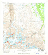
1951 Map of Mount Hayes C-5
USGS Topo · Published 1970About this map
Trident Glacier dominates the western portion of this high-altitude landscape, its expansive flow marked by complex networks of Crevasses. Surveyed in the early 1950s with minor revisions later in the decade, the terrain is defined by the sharp elevations of the Alaska Range, including the towering Mount Moffit and Mount Shand. To the north, the boundary of Fort Greely indicates the military presence in this subarctic wilderness, while the eastern reaches are carved by the Mc Ginnis Glacier descending from Mc Ginnis Peak. The map provides a detailed view of these massive ice fields before mid-century glacial retreat patterns became a primary focus of modern study, preserving the exact mid-century footprints of landmarks like Mount Pillsbury and the remote outpost of Hayes.
Find a feature on this map
10 named features on this map. Tap any name to fly to it.
Don’t see what you’re looking for? This feature index may not catch every label — zoom into the map to look around manually.
Map Details
Editions of this 1951 Mount Hayes C-5 Map
3 editions found
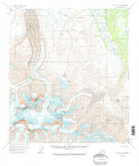
Other maps of this area

1950 · Mount Hayes
USGS Topo · 1:250,000

1950 · Mount Hayes D-4
USGS Topo · 1:63,360

1950 · Mount Hayes C-4
USGS Topo · 1:63,360

1950 · Mount Hayes D-6
USGS Topo · 1:63,360

1950 · Mount Hayes D-5
USGS Topo · 1:63,360

1951 · Mount Hayes
USGS Topo · 1:250,000

1951 · Mount Hayes B-6
USGS Topo · 1:63,360

1951 · Mount Hayes C-5
USGS Topo · 1:63,360

1951 · Mt. Hayes B-5
USGS Topo · 1:63,360

1951 · Mount Hayes C-6
USGS Topo · 1:63,360