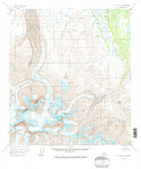
1951 Map of Mount Hayes C-5
USGS Topo · Published 1970About this map
Fort Greely occupies the northern reaches of this mid-century survey, where the Alaska Range transitions from high alpine ice to the lower reaches of the interior. The landscape is dominated by massive ice flows, most notably the Trident Glacier and Mc Ginnis Glacier, which carve deep valleys between some of the region's most prominent summits. High peaks such as Mount Moffit, Mount Shand, and McGinnis Peak rise above extensive fields of crevasses, marking a territory defined by glacial activity rather than human settlement. In the northwest, Hayes Cr drains the meltwater from the towering heights near VABM 4862 Glacier. This edition reflects the area's geography as documented shortly after the war, showing a purely topographical environment where surveying markers like VABM 7497 Gale serve as the primary human touchpoints in an otherwise wild expanse.
Find a feature on this map
12 named features on this map. Tap any name to fly to it.
Don’t see what you’re looking for? This feature index may not catch every label — zoom into the map to look around manually.
Map Details
Editions of this 1951 Mount Hayes C-5 Map
3 editions found
Other maps of this area

1950 · Mount Hayes
USGS Topo · 1:250,000

1950 · Mount Hayes D-4
USGS Topo · 1:63,360

1950 · Mount Hayes C-4
USGS Topo · 1:63,360

1950 · Mount Hayes D-6
USGS Topo · 1:63,360

1950 · Mount Hayes D-5
USGS Topo · 1:63,360

1951 · Mount Hayes
USGS Topo · 1:250,000

1951 · Mount Hayes B-6
USGS Topo · 1:63,360

1951 · Mount Hayes C-5
USGS Topo · 1:63,360

1951 · Mt. Hayes B-5
USGS Topo · 1:63,360

1951 · Mount Hayes C-6
USGS Topo · 1:63,360