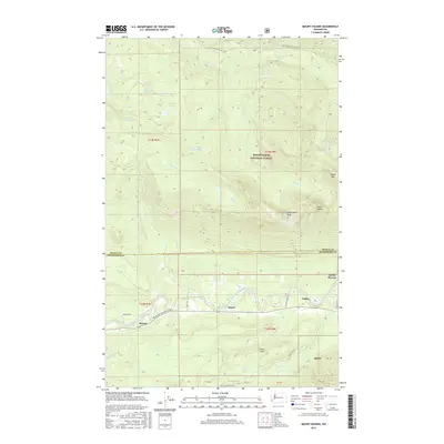
2017 Map of Mount Higgins
USGS Topo · Published 2017About this map
Hazel and Swede Heaven occupy the valley floor along the North Fork Stillaguamish River, marking the primary residential and transport corridor through this corner of the Mount Baker National Forest. The Arlington-Darrington Rd serves as the main artery, connecting the small settlements of Rowan and Tulker. The terrain shifts dramatically from the riverbanks to the high elevations of Mount Higgins and Skadulgwas Peak, where numerous alpine water bodies like Myrtle Lake, Granite Lake, and Shelf Lake are tucked into the high ridges. To the south, the Boulder River and French Cr drain the slopes near French Point, illustrating the complex drainage systems that define the Skagit and Snohomish county line. This geography highlights a landscape where human habitation is concentrated in a narrow valley beneath massive, forested peaks and protected wilderness areas.
Find a feature on this map
45 named features on this map. Tap any name to fly to it.
Don’t see what you’re looking for? This feature index may not catch every label — zoom into the map to look around manually.
Map Details
Editions of this 2017 Mount Higgins Map
This is the sole edition of this map. No revisions or reprints were ever made.
Other maps of this area

1899 · Stillaguamish
USGS Topo · 1:125,000

1901 · Stilaguamish
USGS Topo · 1:125,000

1955 · Concrete
USGS Topo · 1:250,000

1956 · Oso
USGS Topo · 1:62,500

1956 · Granite Falls
USGS Topo · 1:62,500

1957 · Silverton
USGS Topo · 1:62,500

1958 · Concrete
USGS Topo · 1:250,000

1962 · Concrete
USGS Topo · 1:250,000
1966 · Fortson
USGS Topo · 1:24,000
1966 · Finney Peak
USGS Topo · 1:24,000