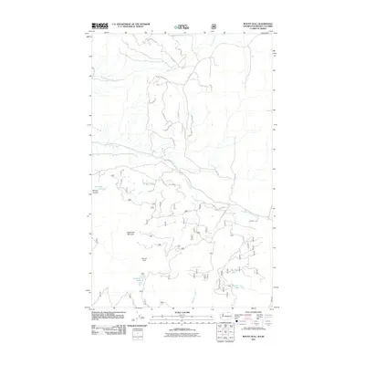
2011 Map of Mount Hull
USGS Topo · Published 2011About this map
Mount Hull and McDonald Mountain anchor this high-country landscape within the Okanogan National Forest. The map documents a complex drainage system where Ninemile Creek and Tomasket Creek carve through the terrain, punctuated by isolated water bodies like Fertilizer Lake and Mud Lake. The road network, including Chesaw Rd and Old Trestle Rd, reflects the area's history of resource management and rural access.
Find a feature on this map
37 named features on this map. Tap any name to fly to it.
Don’t see what you’re looking for? This feature index may not catch every label — zoom into the map to look around manually.
Map Details
Editions of this 2011 Mount Hull Map
This is the sole edition of this map. No revisions or reprints were ever made.
Other maps of this area

1902 · Osoyoos
USGS Topo · 1:125,000

1904 · Osoyoos
USGS Topo · 1:125,000

1954 · Okanogan
USGS Topo · 1:250,000

1957 · Mt. Bonaparte
USGS Topo · 1:62,500

1957 · Oroville
USGS Topo · 1:62,500

1958 · Okanogan
USGS Topo · 1:250,000

1975 · Oroville NW
USGS Topo · 1:24,000
1981 · Burge Mtn
USGS Topo · 1:24,000

1981 · Mount Hull
USGS Topo · 1:24,000
1982 · Ellisforde
USGS Topo · 1:24,000