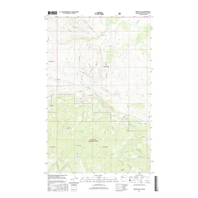
2017 Map of Mount Hull
USGS Topo · Published 2017About this map
Mount Hull towers over this pocket of the Okanogan National Forest, anchoring a landscape defined by high-elevation ridges and small alpine water bodies. The terrain descends into Whistler Canyon and several named drainage basins including Ninemile Cr and Tomasket Cr. The map reveals a dense network of forest service and access roads such as Chesaw Rd and Molson Rd, providing insight into the modern management and recreational use of these public lands. Scattered across the highlands are remote water sources and minor basins like Fertilizer Lake, Cockle Spring, and Summit Lake. These features, along with prominent peaks like McDonald Mtn and Haley Mtn, illustrate the complex topography of the Okanogan region near the international border.
Find a feature on this map
56 named features on this map. Tap any name to fly to it.
Don’t see what you’re looking for? This feature index may not catch every label — zoom into the map to look around manually.
Map Details
Editions of this 2017 Mount Hull Map
This is the sole edition of this map. No revisions or reprints were ever made.
Other maps of this area

1902 · Osoyoos
USGS Topo · 1:125,000

1904 · Osoyoos
USGS Topo · 1:125,000

1954 · Okanogan
USGS Topo · 1:250,000

1957 · Mt. Bonaparte
USGS Topo · 1:62,500

1957 · Oroville
USGS Topo · 1:62,500

1958 · Okanogan
USGS Topo · 1:250,000

1975 · Oroville NW
USGS Topo · 1:24,000
1981 · Burge Mtn
USGS Topo · 1:24,000

1981 · Mount Hull
USGS Topo · 1:24,000
1982 · Ellisforde
USGS Topo · 1:24,000