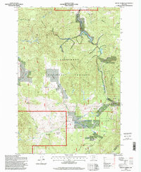
1996 Map of Mount Humbug
USGS Topo · Published 1998About this map
The Continental Divide serpentines through this 1996 survey, defining the high-altitude landscape where Silver Bow and Madison counties meet. This area, managed largely within the Deerlodge National Forest, is dominated by the prominent peak of Mount Humbug and the surrounding drainage networks of Basin Creek and Moose Creek. The map documents a rugged history of resource extraction, illustrated by the numerous Prospect and Mine Shaft symbols clustered near the small settlement of Moose Town. Water management is central to the area's geography, with the Basin Creek Reservoir and Upper Reservoir capturing runoff from the surrounding gulches. These reservoirs and the varied terrain of Maloney Park and Gold Hill are accessible via several forest routes, including the Highland Road and Burton Park Road.
Find a feature on this map
32 named features on this map. Tap any name to fly to it.
Don’t see what you’re looking for? This feature index may not catch every label — zoom into the map to look around manually.
Map Details
Editions of this 1996 Mount Humbug Map
This is the sole edition of this map. No revisions or reprints were ever made.
Other maps of this area

1893 · Dillon
USGS Topo · 1:250,000

1955 · Dillon
USGS Topo · 1:250,000

1957 · Dillon
USGS Topo · 1:250,000

1958 · Dillon
USGS Topo · 1:250,000

1960 · Twin Bridges
USGS Topo · 1:62,500

1961 · Melrose
USGS Topo · 1:24,000

1961 · Wickiup Creek
USGS Topo · 1:24,000

1961 · Butte South
USGS Topo · 1:62,500

1962 · Dillon
USGS Topo · 1:250,000

1963 · Pipestone Pass
USGS Topo · 1:24,000