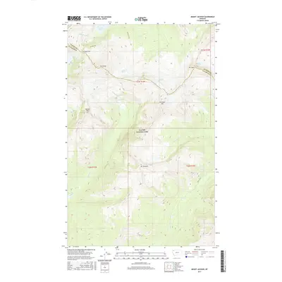
2017 Map of Mount Jackson
USGS Topo · Published 2017About this map
Glacier National Park contains some of the most dramatic high-altitude features of the Continental Divide, shown here along the boundary of Glacier and Flathead counties. The landscape is dominated by massive peaks and glacial remnants, including Mt Jackson, Mt Logan, and Blackfoot Mtn. This 2017 survey documents the extent of the Blackfoot Glacier, Jackson Glacier, and Logan Glacier during a period of intense focus on these shrinking ice masses. The drainage patterns are defined by the Saint Mary River and numerous high-mountain creeks like Virginia Cr and Nyack Creek. For those interested in the wilderness corridors of the northern Rockies, the map provides precise locations for Gunsight Pass and secluded water bodies like Lake Ellen Wilson and Harrison Lake. This record of the high backcountry serves as a detailed topographical account of one of North America's most protected alpine environments.
Find a feature on this map
27 named features on this map. Tap any name to fly to it.
Don’t see what you’re looking for? This feature index may not catch every label — zoom into the map to look around manually.
Map Details
Editions of this 2017 Mount Jackson Map
This is the sole edition of this map. No revisions or reprints were ever made.
Other maps of this area

1904 · Chief Mountain
USGS Topo · 1:125,000

1914 · Nyack
USGS Topo · 1:125,000

1938 · Chief Mountain
USGS Topo · 1:125,000

1960 · Cut Bank
USGS Topo · 1:250,000

1963 · Cut Bank
USGS Topo · 1:250,000

1964 · Cut Bank
USGS Topo · 1:250,000

1964 · Nyack
USGS Topo · 1:24,000

1964 · Stanton Lake
USGS Topo · 1:24,000
1964 · Mount Saint Nicholas
USGS Topo · 1:24,000
1968 · Mount Cannon
USGS Topo · 1:24,000