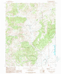
1989 Map of Mount Jackson
USGS Topo · Published 1989About this map
Sweetwater Mountains and the New Bull Range dominate this high-altitude landscape in Mono County, where complex drainage systems like Swauger Creek and Huntoon Creek flow toward the lower basins. The map captures a moment in the late 1980s when the region was primarily managed as part of the Toiyabe National Forest. Human presence is sparse, marked by seasonal or resource-based sites such as Pimentel Meadows and the isolated Log Cabin located near the eponymous Log Cabin Creek.
Find a feature on this map
29 named features on this map. Tap any name to fly to it.
Don’t see what you’re looking for? This feature index may not catch every label — zoom into the map to look around manually.
Map Details
Editions of this 1989 Mount Jackson Map
2 editions found
Other maps of this area

1909 · Bridgeport
USGS Topo · 1:125,000

1911 · Bridgeport
USGS Topo · 1:125,000

1920 · Bridgeport
USGS Topo · 1:125,000

1948 · Walker Lake
USGS Topo · 1:250,000

1954 · Chris Flat
USGS Topo · 1:24,000

1954 · Fales Hot Springs
USGS Topo · 1:24,000

1956 · Fales Hot Springs
USGS Topo · 1:62,500

1956 · Matterhorn Peak
USGS Topo · 1:62,500

1957 · Walker Lake
USGS Topo · 1:250,000

1958 · Bodie
USGS Topo · 1:62,500