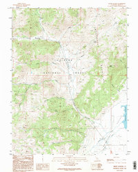
1989 Map of Mount Jackson
USGS Topo · Published 1995About this map
Toiyabe National Forest dominates this high-altitude landscape in Mono County, where the eastern slopes of the Sweetwater Mountains drop into the open expanses of the Bridgeport Valley. Based on 1980s aerial photography, the map details a drainage network defined by Swauger Creek and Huntoon Valley, where seasonal flows carve through numerous canyons like Patterson Canyon and Yaney Canyon.
Find a feature on this map
26 named features on this map. Tap any name to fly to it.
Don’t see what you’re looking for? This feature index may not catch every label — zoom into the map to look around manually.
Map Details
Editions of this 1989 Mount Jackson Map
2 editions found
Other maps of this area

1909 · Bridgeport
USGS Topo · 1:125,000

1911 · Bridgeport
USGS Topo · 1:125,000

1920 · Bridgeport
USGS Topo · 1:125,000

1948 · Walker Lake
USGS Topo · 1:250,000

1954 · Chris Flat
USGS Topo · 1:24,000

1954 · Fales Hot Springs
USGS Topo · 1:24,000

1956 · Fales Hot Springs
USGS Topo · 1:62,500

1956 · Matterhorn Peak
USGS Topo · 1:62,500

1957 · Walker Lake
USGS Topo · 1:250,000

1958 · Bodie
USGS Topo · 1:62,500