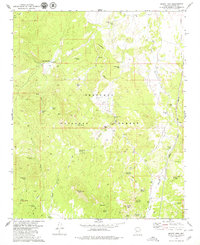
1979 Map of Mount Josh
USGS Topo · Published 1979About this map
Prescott National Forest dominates this Yavapai County landscape, revealing a remote terrain defined by high-elevation springs and scattered ranching outposts. Recorded in the late 1970s, the map highlights isolated settlements like Old Camp Farm and Moana Ranch, which are connected by a network of pack trails and jeep tracks. The presence of numerous family-named and evocative water sources, such as Bootlegger Spring, Jack Jones Spring, and Black Jack Spring, speaks to the critical importance of water management in this arid environment. To the east, the Atchison Topeka and Santa Fe railroad corridor runs through the lowlands, providing a sharp industrial contrast to the high peaks of Mount Josh and Tonto Mtn. A single Mine near Tonto Wash hints at the mineral prospecting history that shaped this section of Arizona's interior.
Find a feature on this map
49 named features on this map. Tap any name to fly to it.
Don’t see what you’re looking for? This feature index may not catch every label — zoom into the map to look around manually.
Map Details
Editions of this 1979 Mount Josh Map
2 editions found
Other maps of this area

1887 · Prescott
USGS Topo · 1:250,000

1892 · Prescott
USGS Topo · 1:250,000

1947 · Simmons
USGS Topo · 1:62,500

1947 · Iron Springs
USGS Topo · 1:62,500

1947 · Sheridan Mountain
USGS Topo · 1:62,500

1947 · Camp Wood
USGS Topo · 1:62,500

1948 · Sheridan Mountain
USGS Topo · 1:63,360

1948 · Iron Springs
USGS Topo · 1:63,360

1948 · Camp Wood
USGS Topo · 1:63,360

1948 · Simmons
USGS Topo · 1:63,360