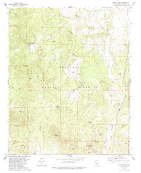
1979 Map of Mount Josh
USGS Topo · Published 1985About this map
Prescott National Forest dominates this Yavapai County landscape, defined by high-elevation springs and a network of ephemeral washes. Settled outposts like Old Camp Farm and the Moana Ranch reflect the region's agricultural and ranching history in the late 1970s. The terrain is marked by distinctive peaks such as Mount Josh and Tonto Mtn, with the dry bed of Strickland Wash cutting through the center. Water management is central to the area's utility, evidenced by the numerous named tanks and springs, including Bootlegger Spring, Jack Jones Spring, and Pemberton Tank. Along the eastern edge, the industrial presence of the Atchison Topeka and Santa Fe railroad provides a stark contrast to the surrounding backcountry trails. These trails, often marked as a Jeep Trail, connect scattered landmarks like a lone Mine and various corrals used for livestock.
Find a feature on this map
47 named features on this map. Tap any name to fly to it.
Don’t see what you’re looking for? This feature index may not catch every label — zoom into the map to look around manually.
Map Details
Editions of this 1979 Mount Josh Map
2 editions found
Other maps of this area

1887 · Prescott
USGS Topo · 1:250,000

1892 · Prescott
USGS Topo · 1:250,000

1947 · Simmons
USGS Topo · 1:62,500

1947 · Iron Springs
USGS Topo · 1:62,500

1947 · Sheridan Mountain
USGS Topo · 1:62,500

1947 · Camp Wood
USGS Topo · 1:62,500

1948 · Sheridan Mountain
USGS Topo · 1:63,360

1948 · Iron Springs
USGS Topo · 1:63,360

1948 · Camp Wood
USGS Topo · 1:63,360

1948 · Simmons
USGS Topo · 1:63,360