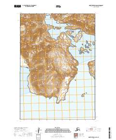
2019 Map of Mount Katmai A-2 SW
USGS Topo · Published 2019About this map
Katmai National Park encompasses the entire landscape of this coastal survey, defined by the intricate contact between the Aleutian Range and the Pacific Ocean. The coastline is heavily indented by glacial fjords, most notably the sheltered waters of Geographic Harbor and Amalik Bay in the northeast, and Dakavak Bay to the west. These deep-water inlets are separated by high, ridged peninsulas that terminate at landmarks like Cape Ilktugitak. The lack of man-made infrastructure on this 2019 sheet emphasizes the preservation of the area's natural hydrography and terrain, providing a clear record of the shoreline and elevation contours as they existed in the early 21st century.
Find a feature on this map
10 named features on this map. Tap any name to fly to it.
Don’t see what you’re looking for? This feature index may not catch every label — zoom into the map to look around manually.
Map Details
Editions of this 2019 Mount Katmai A-2 SW Map
This is the sole edition of this map. No revisions or reprints were ever made.
Other maps of this area

1948 · Mt Katmai
USGS Topo · 1:250,000

1951 · Mt Katmai
USGS Topo · 1:250,000

1951 · Karluk
USGS Topo · 1:250,000

1951 · Mount Katmai A-3
USGS Topo · 1:63,360

1951 · Mount Katmai A-2
USGS Topo · 1:63,360

1952 · Karluk
USGS Topo · 1:250,000

1964 · Mt. Katmai
USGS Topo · 1:250,000

1964 · Karluk
USGS Topo · 1:250,000
2019 · Mount Katmai A-3 NE
USGS Topo · 1:25,000
2019 · Mount Katmai A-2 NE
USGS Topo · 1:25,000