
1951 Map of Mount Katmai A-3
USGS Topo · Published 1956About this map
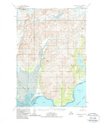
The Katmai Village Site sits at the edge of Katmai Bay, marking a significant point of human history along the Alutiiq coastline within Katmai National Monument. This 1950s study details the complex drainage systems where the Katmai River and Soluka Creek meet the tidal flats of the Shelikof Strait. The interior is dominated by the steep elevations of the Barrier Range and distinctive peaks such as Painted Mountain and Mt Pedmar. These topographic details illustrate the geographic isolation of the region decades after the Novarupta eruption, showing the land as it recovered. Further east, the map traces the shoreline of Dakavak Bay and the tucked-away Dakavak Lake, providing a clear record of the coastal terrain before modern changes in the monument's management.
Find a feature on this map
16 named features on this map. Tap any name to fly to it.
Don’t see what you’re looking for? This feature index may not catch every label — zoom into the map to look around manually.
Map Details
Editions of this 1951 Mount Katmai A-3 Map
2 editions found
Other maps of this area

1948 · Mt Katmai
USGS Topo · 1:250,000

1951 · Mt Katmai
USGS Topo · 1:250,000

1951 · Karluk
USGS Topo · 1:250,000

1951 · Mount Katmai B-4
USGS Topo · 1:63,360

1951 · Karluk D-4
USGS Topo · 1:63,360

1951 · Mount Katmai A-2
USGS Topo · 1:63,360

1951 · Mount Katmai A-4
USGS Topo · 1:63,360

1951 · Mount Katmai B-3
USGS Topo · 1:63,360

1951 · Mount Katmai B-2
USGS Topo · 1:63,360

1952 · Karluk
USGS Topo · 1:250,000