
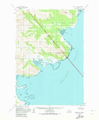
1951 Map of Karluk D-4
USGS Topo · Published 1956About this map
Katmai National Monument dominates the northern half of this coastal survey, where the rugged terrain of the Alaska Peninsula meets the Shelikof Strait. The landscape is defined by massive peaks like Mt Kubugakli and Atmo Mountain, which tower over deeply indented waters. The boundary of the monument cuts diagonally across the center, separating protected lands from the southern reaches around Alinchak Bay. Along the shoreline, extensive Tidal Flats characterize the transition between the mountains and the sea, particularly within Kashvik Bay. A solitary Cabin near the coast provides a rare sign of human presence in this wilderness, while surveying markers such as VABM Kubugakli and coastal landmarks like Cape Kubugakli help orient travelers navigating the treacherous waters of Katmai Bay.
Find a feature on this map
12 named features on this map. Tap any name to fly to it.
Don’t see what you’re looking for? This feature index may not catch every label — zoom into the map to look around manually.
Map Details
Editions of this 1951 Karluk D-4 Map
2 editions found
Other maps of this area

1948 · Mt Katmai
USGS Topo · 1:250,000

1951 · Mt Katmai
USGS Topo · 1:250,000

1951 · Karluk
USGS Topo · 1:250,000

1951 · Mount Katmai A-3
USGS Topo · 1:63,360
1951 · Karluk C-4 and C-5
USGS Topo · 1:63,360

1951 · Mount Katmai A-4
USGS Topo · 1:63,360

1951 · Karluk D-5
USGS Topo · 1:63,360

1951 · Mount Katmai A-5
USGS Topo · 1:63,360

1952 · Karluk
USGS Topo · 1:250,000

1964 · Mt. Katmai
USGS Topo · 1:250,000