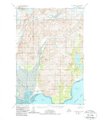
1951 Map of Mount Katmai A-3
USGS Topo · Published 1979About this map
The Katmai Village Site sits along the northern edge of Katmai Bay, marking a place of historical human presence on the edge of the Shelikof Strait. This coastal area is dominated by the massive topography of Mt Katmai and the Barrier Range, where the Katmai River has carved a deep Canyon as it flows toward the sea. The geography reflects a landscape defined by volcanic and glacial forces, as seen in the elevation profiles of Painted Mountain and Mt Pedmar.
Find a feature on this map
16 named features on this map. Tap any name to fly to it.
Don’t see what you’re looking for? This feature index may not catch every label — zoom into the map to look around manually.
Map Details
Editions of this 1951 Mount Katmai A-3 Map
2 editions found
Other maps of this area

1948 · Mt Katmai
USGS Topo · 1:250,000

1951 · Mt Katmai
USGS Topo · 1:250,000

1951 · Karluk
USGS Topo · 1:250,000

1951 · Mount Katmai A-3
USGS Topo · 1:63,360

1951 · Mount Katmai B-4
USGS Topo · 1:63,360

1951 · Karluk D-4
USGS Topo · 1:63,360

1951 · Mount Katmai A-2
USGS Topo · 1:63,360

1951 · Mount Katmai A-4
USGS Topo · 1:63,360

1951 · Mount Katmai B-3
USGS Topo · 1:63,360

1951 · Mount Katmai B-2
USGS Topo · 1:63,360