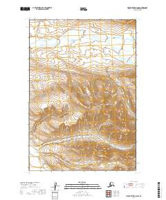
2019 Map of Mount Katmai A-5 NW
USGS Topo · Published 2019About this map
Katmai National Park encompasses this entire sub-quadrangle, showcasing a landscape defined by the drainage of Angle Creek and the southern extent of the Kejulik Mountains. This 2019 survey provides a meticulous record of the high-altitude terrain where peaks reach elevations exceeding 3,000 feet. The cartography illustrates a complex network of glacial valleys and ridges, primarily within the Township 23 South, Range 39 West and Range 38 West boundaries. The lack of human infrastructure or established settlements underscores the primitive nature of this section of the Alaska Peninsula. For those studying the hydrology and landforms of the park, the map details how Angle Creek meanders through the flatter northern basins before the topography rises sharply into the ridgelines of the Kejulik range.
Find a feature on this map
10 named features on this map. Tap any name to fly to it.
Don’t see what you’re looking for? This feature index may not catch every label — zoom into the map to look around manually.
Map Details
Editions of this 2019 Mount Katmai A-5 NW Map
This is the sole edition of this map. No revisions or reprints were ever made.
Other maps of this area

1948 · Mt Katmai
USGS Topo · 1:250,000

1951 · Mt Katmai
USGS Topo · 1:250,000

1951 · Mount Katmai A-6
USGS Topo · 1:63,360

1951 · Mount Katmai B-6
USGS Topo · 1:63,360

1951 · Mount Katmai B-5
USGS Topo · 1:63,360

1951 · Mount Katmai A-5
USGS Topo · 1:63,360
1953 · Mt. Katmai B-6
USGS Topo · 1:63,360
1953 · Mount Katmai B-5
USGS Topo · 1:63,360

1964 · Mt. Katmai
USGS Topo · 1:250,000
2019 · Mount Katmai A-5 SE
USGS Topo · 1:25,000