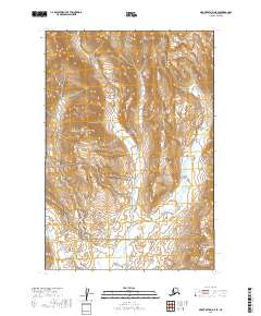
2019 Map of Mount Katmai A-5 SE
USGS Topo · Published 2019About this map
The Kejulik River carves a central path through this wilderness landscape, serving as a geographic boundary between two major federal conservation areas. The northern half of the sheet is dominated by the steep slopes of the Kejulik Mountains within Katmai National Park, while the southern reaches descend into the protected wetlands and tundra of the Becharof National Wildlife Refuge. This intersection of protected lands highlights a remote section of the Alaska Peninsula where the high-altitude peaks give way to the drainage basin of Gas Cr. The terrain is characterized by sharp elevation changes and the absence of human infrastructure, focusing instead on the natural hydrology and township boundaries like t24s r38w and t25s r37w that define these expansive wildlife corridors.
Find a feature on this map
9 named features on this map. Tap any name to fly to it.
Don’t see what you’re looking for? This feature index may not catch every label — zoom into the map to look around manually.
Map Details
Editions of this 2019 Mount Katmai A-5 SE Map
This is the sole edition of this map. No revisions or reprints were ever made.
Other maps of this area

1948 · Mt Katmai
USGS Topo · 1:250,000

1951 · Mt Katmai
USGS Topo · 1:250,000

1951 · Karluk
USGS Topo · 1:250,000

1951 · Karluk D-4
USGS Topo · 1:63,360

1951 · Mount Katmai A-4
USGS Topo · 1:63,360

1951 · Karluk D-5
USGS Topo · 1:63,360

1951 · Mount Katmai A-5
USGS Topo · 1:63,360

1952 · Karluk
USGS Topo · 1:250,000

1964 · Mt. Katmai
USGS Topo · 1:250,000

1964 · Karluk
USGS Topo · 1:250,000