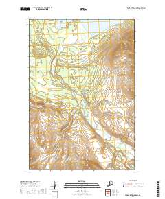
2019 Map of Mount Katmai B-5 NW
USGS Topo · Published 2019About this map
Katmai National Park encompasses this entire portion of the Lake and Peninsula Borough, where the dramatic volcanic landscape is defined by the winding course of the Valley of Ten Thousand Smokes Road. This primitive route meanders through the interior wilderness, crossing various drainage systems like Margot Cr as it provides access to one of the most geologically significant regions in Alaska. The northern edge of the map reaches the shores of Naknek Lake, a massive body of water that serves as a critical geographic marker for the region's hydrology. The topographic contours reveal a landscape of sharp elevations and deep valleys, illustrating the aftermath of the 1912 Novarupta eruption that forever altered these surroundings. This survey captures the preservation of this wilderness area into the twenty-first century, showing the intersection of park management infrastructure and the raw natural features of the Alaskan Peninsula.
Find a feature on this map
10 named features on this map. Tap any name to fly to it.
Don’t see what you’re looking for? This feature index may not catch every label — zoom into the map to look around manually.
Map Details
Editions of this 2019 Mount Katmai B-5 NW Map
This is the sole edition of this map. No revisions or reprints were ever made.
Other maps of this area

1948 · Mt Katmai
USGS Topo · 1:250,000

1951 · Mt Katmai
USGS Topo · 1:250,000

1951 · Mount Katmai C-6
USGS Topo · 1:63,360

1951 · Mount Katmai B-6
USGS Topo · 1:63,360

1951 · Mount Katmai C-5
USGS Topo · 1:63,360

1951 · Mount Katmai B-5
USGS Topo · 1:63,360
1953 · Mt. Katmai B-6
USGS Topo · 1:63,360
1953 · Mount Katmai B-5
USGS Topo · 1:63,360
1953 · Mount Katmai C-5
USGS Topo · 1:63,360

1964 · Mt. Katmai
USGS Topo · 1:250,000