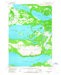
1953 Map of Mount Katmai C-5
USGS Topo · Published 1968About this map
Katmai National Monument encompasses this vast aquatic landscape in Southwest Alaska, defined by a series of interconnected glacial lakes and high mountain peaks. Mount La Gorce dominates the central peninsula, rising between the southern reaches of Lake Coville and the northern waters of Naknek Lake (Iliuk Arm). The map illustrates a complex network of waterways, including the island-dotted Bay of Islands and the long expanse of Lake Grosvenor. Photogrammetric methods from 1951 aerial surveys reveal a landscape where water and terrain are the primary features, as the margin notes no roads or trails existed in this area during the early 1950s. This survey records the shoreline configurations of Naknek Lake (North Arm) before significant modern environmental shifts, serving as a baseline for the region's wilderness character.
Find a feature on this map
7 named features on this map. Tap any name to fly to it.
Don’t see what you’re looking for? This feature index may not catch every label — zoom into the map to look around manually.
Map Details
Editions of this 1953 Mount Katmai C-5 Map
This is the sole edition of this map. No revisions or reprints were ever made.
Other maps of this area

1948 · Mt Katmai
USGS Topo · 1:250,000

1951 · Mt Katmai
USGS Topo · 1:250,000

1951 · Mount Katmai B-4
USGS Topo · 1:63,360

1951 · Mount Katmai C-6
USGS Topo · 1:63,360

1951 · Mount Katmai B-6
USGS Topo · 1:63,360

1951 · Mount Katmai D-5
USGS Topo · 1:63,360

1951 · Mount Katmai C-5
USGS Topo · 1:63,360

1951 · Mount Katmai D-6
USGS Topo · 1:63,360

1951 · Mount Katmai C-4
USGS Topo · 1:63,360

1951 · Mount Katmai D-4
USGS Topo · 1:63,360