
1951 Map of Mount Katmai C-4
USGS Topo · Published 1956About this map
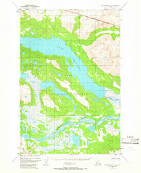
Katmai National Monument defines this landscape, captured during a 1951 aerial survey of the Alaska Peninsula. The terrain is dominated by the massive Lake Grosvenor, which stretches across the center of the sheet, framed by steep elevations that rise sharply from the shoreline. To the south, the intricate braided channels of the Savonoski River indicate a complex glacial outwash system, where the riverbed spreads wide across a low-lying valley before meeting the Ukak River. The lack of any named settlements or roads highlights the wilderness character of the region during the early 1950s, focusing instead on water systems like Hardscrabble Creek and Ikagluik Creek. This survey serves as a vital record of the monument's hydrology and topography before any significant human infrastructure or changes in the volcanic landscape occurred.
Find a feature on this map
7 named features on this map. Tap any name to fly to it.
Don’t see what you’re looking for? This feature index may not catch every label — zoom into the map to look around manually.
Map Details
Editions of this 1951 Mount Katmai C-4 Map
2 editions found
Other maps of this area

1948 · Mt Katmai
USGS Topo · 1:250,000

1951 · Mt Katmai
USGS Topo · 1:250,000

1951 · Mount Katmai C-3
USGS Topo · 1:63,360

1951 · Mount Katmai B-4
USGS Topo · 1:63,360

1951 · Mount Katmai D-5
USGS Topo · 1:63,360

1951 · Mount Katmai C-5
USGS Topo · 1:63,360

1951 · Mount Katmai D-4
USGS Topo · 1:63,360

1951 · Mount Katmai D-3
USGS Topo · 1:63,360

1951 · Mount Katmai B-3
USGS Topo · 1:63,360

1951 · Mount Katmai B-5
USGS Topo · 1:63,360